 Filter: Categories of Wisconsin Historical Images
Filter: Subject of Land
Filter: Community of Greendale
Filter: Categories of Wisconsin Historical Images
Filter: Subject of Land
Filter: Community of Greendale
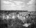
| Date: | 1940 |
|---|---|
| Description: | Elevated view over trees of village. In the background is a water tower on a hill with trees. |
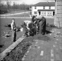
| Date: | 1938 |
|---|---|
| Description: | Four men planting shrubbery along the edge of a brick patio area outside of the Administration Building. A duplex house is visible in the background. |

| Date: | 1960 |
|---|---|
| Description: | This map of Greedale shows local streets, parks, schools, and churches and includes manuscript annotations in green and blue showing tracts and parcels of ... |

| Date: | 1938 |
|---|---|
| Description: | This map shows buildings, lots, parks, schools, pumping stations, sites reserved for churches, and water towers. |

| Date: | 1964 |
|---|---|
| Description: | This map shows various zoning sections and includes labeled streets, parks, and cemeteries. The upper left corner contains a legend of land use. |
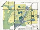
| Date: | 1962 |
|---|---|
| Description: | This map shows zoning, community facilities, roads, rivers and thoroughfares. The lower right corner includes a key titled "General Plan". |
If you didn't find the material you searched for, our Library Reference Staff can help.
Call our reference desk at 608-264-6535 or email us at: