 Filter: Categories of Wisconsin Historical Images
Filter: Subject of Land
Filter: Community of Eau Claire
Filter: Categories of Wisconsin Historical Images
Filter: Subject of Land
Filter: Community of Eau Claire

| Date: | 1872 |
|---|---|
| Description: | Birds-eye drawing of Eau Claire depicts street names and street locations, houses, trees, bridges, piers, canals, railroads, and the Chippewa and Eau Clair... |

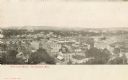
| Date: | 1891 |
|---|---|
| Description: | Bird's-eye view of Eau Claire. |
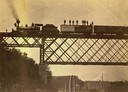
| Date: | 09 01 1882 |
|---|---|
| Description: | View looking up towards the special train of the Chicago, St. Paul, Minneapolis & Omaha Railroad comprised of 24 freight cars loaded with lumber and other ... |

| Date: | 1930 |
|---|---|
| Description: | Aerial view of Carson Park, Half Moon Lake and part of the West Side in the foreground. The municipal bath house is on the lake shore in the foreground. A ... |
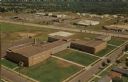
| Date: | |
|---|---|
| Description: | Aerial view of the high school, 2100 Fenwick Avenue, and the surrounding roads. |
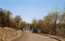
| Date: | |
|---|---|
| Description: | View down a road in the park, leading to a river and a bridge. |
| Date: | |
|---|---|
| Description: | Elevated view of the river with multiple bridges across it, including at least two railroad bridges. There is a factory on the left bank with smokestacks, ... |
| Date: | |
|---|---|
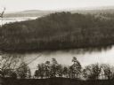
| Description: | Elevated view of the "mount" and the wide river before it and behind it. Houses and smokestacks can be seen in the far distance. |
| Date: | |
|---|---|
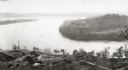
| Description: | Elevated view of a bow in the river, and a homestead on the shore, with a two-story house and a barn. Two wagons are close to the barn in the lower left co... |
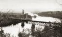
| Date: | |
|---|---|
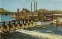
| Description: | Elevated view of the dam and the power plant. A railroad bridge is in the upper left. Three smokestacks are in the background. |
| Date: | |
|---|---|
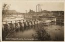
| Description: | View of the mill and the dam, and the river. The area around the mill is heavily forested. Caption reads: "Dells Paper Mill and Dam, Eau Claire, Wis." |
| Date: | 1930 |
|---|---|
| Description: | Elevated view of the dam and the mill, with some trees in the foreground. A railroad bridge is in the background on the left, and a rail cart or truck is d... |
| Date: | 1905 |
|---|---|
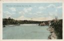
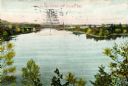
| Description: | Elevated view of the Eau Claire River with a bridge in the background. Caption reads: "Eau Claire River, Eau Claire, Wis." |
| Date: | 1885 |
|---|---|
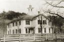
| Description: | The Third Ward, East Side, or Barlett School, after additions had been put on in the rear. The Bartlett after whom the school building was named was Willia... |

| Date: | 1885 |
|---|---|
| Description: | View of Eau Claire from eastside hill near Carter. A man and young child are standing in front of a fence in the foreground. |
| Date: | |
|---|---|
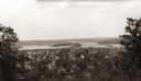
| Description: | Elevated view of the residential section of Eau Claire from Mount Tom. |
| Date: | 1905 |
|---|---|
| Description: | Caption reads: "Bird's-Eye View, Eau Claire Wis." |

| Date: | 1870 |
|---|---|
| Description: | Elevated view of the town, looking northwest. The Chippewa River is in the foreground, with a lot of buildings, an intersection, and distant hills. One bui... |

| Date: | 1906 |
|---|---|
| Description: | Elevated view of downtown Eau Claire. |
If you didn't find the material you searched for, our Library Reference Staff can help.
Call our reference desk at 608-264-6535 or email us at:
