 Filter: Categories of Wisconsin Historical Images
Filter: Subject of Land
Filter: Community of Cedarburg
Filter: Categories of Wisconsin Historical Images
Filter: Subject of Land
Filter: Community of Cedarburg

| Date: | 1882 |
|---|---|
| Description: | This map of Cedarburg is a bird's-eye map with an inset of Cedarburg Brewery. Relief is shown pictorially and the map includes an index to buildings. |
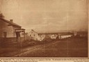
| Date: | 1850 |
|---|---|
| Description: | Main Street in Cedarburg. Includes text which reads: "Cedarburg, Wis., in the year 1850, showing Main Street as it appeared at that time. The photograph wa... |

| Date: | 1938 |
|---|---|
| Description: | This map shows plat of town, boundary lines of assessors blocks, land ownership by name, local streets, railroads, wards, lots, and parts of Cedar Creek. T... |

| Date: | |
|---|---|
| Description: | Hand-colored bird's-eye view down the center of a main street in Cedarburg. Horse and buggy traffic is in the street, with dwellings and buildings on the l... |

| Date: | |
|---|---|
| Description: | Hand-colored elevated view of a residential neighborhood in Cedarburg. There is a church in the background on the left. Caption reads: "Birds [sic] Eye Vie... |

| Date: | |
|---|---|
| Description: | Hand-colored panoramic view of Cedarburg. Dwellings and green space in the foreground. A commercial street running through the center. A windmill is on the... |
If you didn't find the material you searched for, our Library Reference Staff can help.
Call our reference desk at 608-264-6535 or email us at: