 Filter: Categories of Wisconsin Historical Images
Filter: Subject of Land
Filter: Creator Name of Unknown
Filter: County of Dane
Filter: Categories of Wisconsin Historical Images
Filter: Subject of Land
Filter: Creator Name of Unknown
Filter: County of Dane
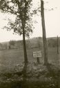
| Date: | 1933 |
|---|---|
| Description: | A posted sign reads: "George Washington Elms, From Mt. Vernon, VA to Mt. Vernon, WIS. Planted May 6th, 1916," at the Forest of Fame, consisting of trees gr... |

| Date: | 1862 |
|---|---|
| Description: | Camp Randall looking southwest. In April 1861, Governor Alexander Randall asked that the State Agricultural Society fairgrounds be converted into a militar... |

| Date: | 1952 |
|---|---|
| Description: | Aerial view of a North Central Airlines DC-3 airplane flying over the Madison isthmus. Clearly visible are the Wisconsin State Capitol, the 1 West Wilson S... |

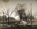
| Date: | 1940 |
|---|---|
| Description: | Aerial view looking east over the center of the city and the University of Wisconsin-Madison campus. |

| Date: | |
|---|---|
| Description: | The Eben Peck cabin was the first house built in Madison. |
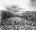
| Date: | 1916 |
|---|---|
| Description: | Maypole dancers at the University of Wisconsin-Madison on Bascom Hill (Main Hill). In the foreground is the Lincoln Monument. In the distance is the Wiscon... |
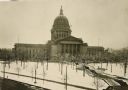
| Date: | 1930 |
|---|---|
| Description: | Elevated view of the west wing of the Wisconsin State Capitol building. A view of the fourth capitol with snow flocked trees and snow-covered lawn and side... |

| Date: | 1873 |
|---|---|
| Description: | Map of the township of Windsor, from the "Atlas of Dane County." |

| Date: | 1861 |
|---|---|
| Description: | Drawn the first year of the Civil War, this colored 1861 map of Dane County shows its towns, cities and lakes. It includes insets of the wards of Madison a... |

| Date: | 1876 |
|---|---|
| Description: | Bird's-eye view of Black Earth. |

| Date: | 1839 |
|---|---|
| Description: | A map of the Wiskonsin [sic] and Neenah or Fox Rivers. |

| Date: | 1897 |
|---|---|
| Description: | A view from the capitol looking west up State Street toward the University of Wisconsin-Madison with the Holy Redeemer Church, Holy Redeemer School, Red Gy... |

| Date: | 1836 |
|---|---|
| Description: | The top map is the "Plat of Madison the Capitol of Wisconsin." The bottom map is the "Map of the Four Lake Country. Taken from the Township Maps in the U.S... |
| Date: | 1909 |
|---|---|
| Description: | A billboard displays events at the foot of Bascom Hill from the bottom east side on the University of Wisconsin-Madison campus. Bascom Hall with dome (form... |
| Date: | 1900 |
|---|---|
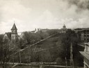
| Description: | The view of Bascom Hill and upper campus of the University of Wisconsin Madison seen from the roof of the Wisconsin Historical Society. |
| Date: | 1900 |
|---|---|
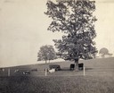
| Description: | Fenced-in, the cattle find a grassy pasture of Observatory Hill below Washburn Observatory on the University of Wisconsin-Madison campus. |

| Date: | 1945 |
|---|---|
| Description: | View of the lower campus of the University of Wisconsin-Madison includes Bascom Hill, Wisconsin Historical Society, Memorial Union and the Armory (Red Gym ... |

| Date: | 1945 |
|---|---|
| Description: | Aerial view of Bascom Hill, Bascom Hall, Wisconsin Historical Society on the University of Wisconsin Madison campus with Lake Mendota on the right. |
| Date: | 1888 |
|---|---|
| Description: | View of shoreline along Picnic Point on the University of Wisconsin-Madison campus showing the home of Professor William Daniels, head of the Chemistry Dep... |
If you didn't find the material you searched for, our Library Reference Staff can help.
Call our reference desk at 608-264-6535 or email us at:
