 Filter: Categories of Wisconsin Historical Images
Filter: Subject of Land
Filter: Type of Map or Atlas
Filter: Categories of Wisconsin Historical Images
Filter: Subject of Land
Filter: Type of Map or Atlas

| Date: | 1673 |
|---|---|
| Description: | P. Marquette en Joliet, gedan in't jaar 1673. |

| Date: | 1880 |
|---|---|
| Description: | This map shows railroads by operator and projected railroads. Portions of Lake Michigan, Lake Superior, Illinois, Iowa, Michigan and Minnesota are labeled. |

| Date: | 1835 |
|---|---|
| Description: | Constructed for the Topographical Bureau [Wash.], 1835. Scale: 16 miles to 1 inch. Map of a portion of the Indian country lying east and west of the Missis... |

| Date: | |
|---|---|
| Description: | This map surveyed under the direction of Capt. Thomas J. Cram is one in a series of seven. The map shows part of the Fox River and the beginning of the tow... |

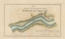
| Date: | 1840 |
|---|---|
| Description: | This map surveyed under the direction of Captain Thomas J. Cram is one in a series of seventeen that accompanied Cram's report on the Fox-Wisconsin river s... |

| Date: | 1840 |
|---|---|
| Description: | This map surveyed under the direction of Captain Thomas J. Cram is one in a series of seventeen that accompanied Cram's report on the Fox-Wisconsin river s... |
| Date: | 1840 |
|---|---|
| Description: | This map surveyed under the direction of Captain Thomas J. Cram is one in a series of seventeen that accompanied Cram's report on the Fox-Wisconsin river s... |
| Date: | 1840 |
|---|---|
| Description: | This map surveyed under the direction of Captain Thomas J. Cram is one in a series of seventeen that accompanied Cram's report on the Fox-Wisconsin river s... |

| Date: | 1840 |
|---|---|
| Description: | This map surveyed under the direction of Captain Thomas J. Cram is one in a series of seventeen that accompanied Cram's report on the Fox-Wisconsin river s... |

| Date: | 1840 |
|---|---|
| Description: | This map surveyed under the direction of Captain Thomas J. Cram is one in a series of seventeen that accompanied Cram's report on the Fox-Wisconsin river s... |

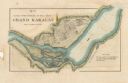
| Date: | 1840 |
|---|---|
| Description: | This map, one of a series made by Thomas Jefferson Cram of the U.S. Topographical Engineers from personal surveys, shows the portage connecting the Wiskons... |

| Date: | 1857 |
|---|---|
| Description: | Information depicting the history, condition and prospects of the Indian tribes of the United States: collected and prepared under the direction of the Bur... |

| Date: | 1896 |
|---|---|
| Description: | Map showing the Wisconsin Central Railroad and its land grant, with the railroad and the land grant in color (red). |

| Date: | 1909 |
|---|---|
| Description: | [Lithography] by Poole Bros. Contains descriptive information. Short jaunts for busy people to nearby resorts in Illinois and Wisconsin. |

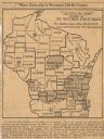
| Date: | 1918 |
|---|---|
| Description: | Map illlustrates creameries, condenseries and cheese factories in Wisconsin, January, 1918, and value of products. Five smaller maps in margin show changes... |

| Date: | 1939 |
|---|---|
| Description: | A color, pictorial map. Scale: 10 miles to the inch. Shows state parks and forests, proposed state parkways, proposed state monuments and memorials, nation... |
| Date: | 1918 |
|---|---|
| Description: | Removed from the "New York Sun," March 21, 1918. Shows "where disloyalty in Wisconsin chiefly centres." Shaded areas indicate regions of suspected pro-Germ... |

| Date: | 1876 |
|---|---|
| Description: | Made from U.S. Surveys and from minutes furnished by Jos. S. Buck and Dr. C. Chase. Scale 20 CHs to an inch. |

| Date: | 1910 |
|---|---|
| Description: | "There never was but one Crop of Land. There never will be another." Shows towns, boundaries, roads, schoolhouses, sawmills, cheese factories, and creameri... |
If you didn't find the material you searched for, our Library Reference Staff can help.
Call our reference desk at 608-264-6535 or email us at:
