Filter: Categories of Wisconsin Historical Images
Filter: Subject of Land
Filter: Type of Drawing
Filter: Categories of Wisconsin Historical Images
Filter: Subject of Land
Filter: Type of Drawing

| Date: | |
|---|---|
| Description: | A preliminary sketch of a landscape with partially drawn cannons in the foreground and tents in the background. |

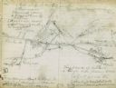
| Date: | 08 10 1862 |
|---|---|
| Description: | A hand-drawn map of the Battle of Wilson's Creek, Springfield, Missouri. Other notes and locations include: "Lyon was killed instantly while heading his tr... |

| Date: | |
|---|---|
| Description: | A hand-drawn map of the state of Missouri with a separate drawing of a map showing Forts Henry and Donelson. The Missouri map includes Jefferson City and s... |
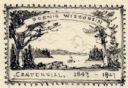
| Date: | 07 1947 |
|---|---|
| Description: | One of two pencil sketches submitted by Leon Pescheret of Whitewater, Wisconsin, to the Wisconsin Centennial Committee to be considered for the Wisconsin C... |

| Date: | |
|---|---|
| Description: | Artists depiction of a natural rock formation called "The Urn," which is 17 feet tall with another 10 feet of trees growing on top of the formation. |
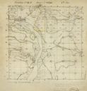
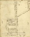
| Date: | 12 01 1851 |
|---|---|
| Description: | Plat map of Wisconsin township 12, North, 9E. |
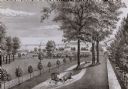
| Date: | |
|---|---|
| Description: | A drawing from Harney's "History of Winnebago County" of E.L. Mathewson's home on Doty Island. |
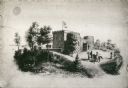
| Date: | 1870 |
|---|---|
| Description: | Benjamin Walker Castle, 1862-1893, 900 block East Gorham Street. There are two deer are the left near trees, and two people are on horseback near the front... |
| Date: | |
|---|---|
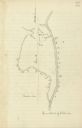
| Description: | Drawn map of the Catawba River, fishing creek, and surrounding landscape from the Sumter Papers. |
| Date: | |
|---|---|
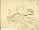
| Description: | Drawn map of the Hanging Rock Battlefield in the Thomas Sumter Papers. |
| Date: | |
|---|---|
| Description: | Drawn map of Hanging Rock Battlefield from the Thomas Sumter Papers. |
| Date: | |
|---|---|
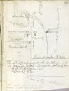
| Description: | Drawn map of Blackstock's Plantation battlefield from the Sumter Papers. |
| Date: | |
|---|---|
| Description: | Drawn map of the Fish Damn Ford battlefield from the Thomas Sumter Papers. |
| Date: | |
|---|---|
| Description: | Drawn map of Blackstock's Plantation battlefield from the Thomas Sumter Papers. |
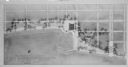
| Date: | 1939 |
|---|---|
| Description: | The proposed Mendota Lake Front Development Plan, William Kaeser, architect. |

| Date: | 1836 |
|---|---|
| Description: | Woodcut of Prairie du Chien in 1836. Text at bottom reads: "Prairie du Chien in 1836. From an old cut." |
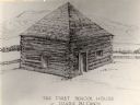
| Date: | 1840 |
|---|---|
| Description: | The first school house at Prairie du Chien, Wisconsin. There is a fence behind the building, and hills in the background. |

| Date: | 1829 |
|---|---|
| Description: | Fort Crawford, from a sketchbook attributed to Seth Eastman, 1808-1875. A graduate of West Point, Eastman briefly served at Fort Crawford, 1829-1839. |
If you didn't find the material you searched for, our Library Reference Staff can help.
Call our reference desk at 608-264-6535 or email us at: