 Filter: Categories of Wisconsin Historical Images
Filter: Subject of Land
Filter: Type of Drawing
Filter: Categories of Wisconsin Historical Images
Filter: Subject of Land
Filter: Type of Drawing

| Date: | 08 24 1876 |
|---|---|
| Description: | Hand-drawn plan of the battleground of Huycks. |

| Date: | 03 26 1876 |
|---|---|
| Description: | Hand-drawn map showing the place of Hook's defeat in York County in South Carolina. |
| Date: | |
|---|---|
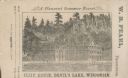
| Description: | View of the Cliff House on the lake, with pine trees surrounding the property, and a cliff behind the building. |
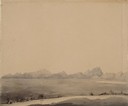
| Date: | 1852 |
|---|---|
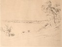
| Description: | Pencil drawing of Black Earth Valley. Gentle lightly tree-covered hills frame the center grassy valley. Two farmhouses are sitting at the base of hills on ... |
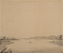
| Date: | 08 1852 |
|---|---|
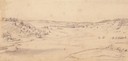
| Description: | Pencil drawing of a lake shoreline. A few trees frame the arc of the shore and steamboats are visible along the distant shore. |

| Date: | 08 1852 |
|---|---|
| Description: | Pencil drawing of Milwaukee Harbor with large sailboats on the water. In the minimalist depiction the sandy shoreline with short plant growth sweeps aroun... |

| Date: | 08 1852 |
|---|---|
| Description: | Pencil drawing of a dirt road through the woods with added white highlights. A horse-drawn wagon with two passengers moves down the road in the distance, ... |
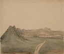
| Date: | 06 20 1849 |
|---|---|
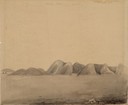
| Description: | The Black Hills sketched by Wilkins on his 151-day journey from Missouri to California on the Overland Trail (also known as the Oregon Trail). |
| Date: | 06 30 1849 |
|---|---|
| Description: | The Red Hills sketched by Wilkins on his 151-day journey from Missouri to California on the Overland Trail (also known as the Oregon Trail). |
| Date: | 06 30 1849 |
|---|---|
| Description: | The Black Hills sketched by Wilkins on his 151-day journey from Missouri to California on the Overland Trail (also known as the Oregon Trail). |
| Date: | 06 30 1849 |
|---|---|
| Description: | The Black Hills sketched by Wilkins on his 151-day journey from Missouri to California on the Overland Trail (also known as the Oregon Trail). |
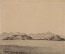
| Date: | 07 03 1849 |
|---|---|
| Description: | The Black Hills sketched by Wilkins on his 151-day journey from Missouri to California on the Overland Trail (also known as the Oregon Trail). |
| Date: | 07 03 1849 |
|---|---|
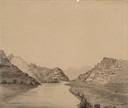
| Description: | Wilkins' wagons ferrying across the North Platte River in eastern Wyoming; sketched by Wilkins on his 151-day journey from Missouri to California on the Ov... |
| Date: | 07 07 1849 |
|---|---|
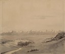
| Description: | The Buttes, Wyoming and Sweetwater River; sketched by Wilkins on his 151-day journey from Missouri to California on the Overland Trail (also known as the O... |
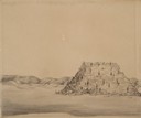
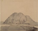
| Date: | 07 10 1849 |
|---|---|
| Description: | The clay hills that were formed by the Sweetwater River in Wyoming; sketched by Wilkins on his 151-day journey from Missouri to California on the Overland ... |
| Date: | 07 10 1849 |
|---|---|
| Description: | Independence Rock (the perceived midway point on the Oregon Trail),Wyoming, with two wagons unhitched at the base of the rock; sketched by Wilkins on his 1... |
| Date: | 07 10 1849 |
|---|---|
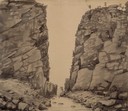
| Description: | Devil's Gate in Wyoming; sketched by Wilkins on his 151-day journey from Missouri to California on the Overland Trail (also known as the Oregon Trail). |
| Date: | 07 11 1849 |
|---|---|
| Description: | Sweetwater River in Wyoming; sketched by Wilkins on his 151-day journey from Missouri to California on the Overland Trail (also known as the Oregon Trail). |
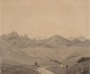
| Date: | 07 12 1849 |
|---|---|
| Description: | Wilkins' first sighting of the Rocky Mountains; sketched by Wilkins on his 151-day journey from Missouri to California on the Overland Trail (also known as... |
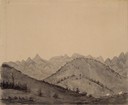
| Date: | 07 13 1849 |
|---|---|
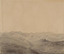
| Description: | The trail at Rocky Ridge, showing wagon train, that Wilkins was taking to get to the South Pass in Wyoming; sketched by Wilkins on his 151-day journey from... |
If you didn't find the material you searched for, our Library Reference Staff can help.
Call our reference desk at 608-264-6535 or email us at: