 Filter: Categories of Wisconsin Historical Images
Filter: Subject of Land
Filter: Type of Drawing
Filter: Categories of Wisconsin Historical Images
Filter: Subject of Land
Filter: Type of Drawing
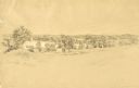
| Date: | 1852 |
|---|---|
| Description: | Pencil drawing of trees around the shore of a lake from across a field. |
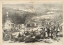
| Date: | 12 17 1862 |
|---|---|
| Description: | Illustration depicting a battle. In the foreground injured soldiers are gathered on and around the porch and yard of a house. In the background are columns... |

| Date: | |
|---|---|
| Description: | Prehistoric Indian earthworks on the middle fork of the Duck River. |

| Date: | 1806 |
|---|---|
| Description: | Prehistoric Indian fortification on Hurricane Creek. |

| Date: | |
|---|---|
| Description: | A plat of Mammoth Cave with detailed descriptive annotations. |

| Date: | |
|---|---|
| Description: | Map of prehistoric mounds near the Big Kanawha River. |

| Date: | |
|---|---|
| Description: | A map of the prehistoric fort at Circleville with annotations by Daniel Drake. |
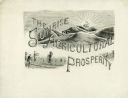
| Date: | 1890 |
|---|---|
| Description: | Original pen and ink drawing of an illustration for a McCormick Company advertising catalog. Features a drawing of men holding grain cradles in a wheat fie... |
| Date: | 1957 |
|---|---|
| Description: | Pencil on vellum drawing of the exterior of the Joseph Hafen residence designed and drawn by architect John Randal McDonald. |
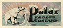
| Date: | 07 02 1935 |
|---|---|
| Description: | Label submitted to the State of Wisconsin for trademark registration. Features a polar bear licking a large ice cream cone. There are floating blocks of ic... |
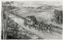
| Date: | 1948 |
|---|---|
| Description: | Drawing of a Madison to Prairie du Chien stage coach in 1848. The coach is driven by two men and drawn by four horses as it passes a farm field separated f... |

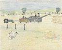
| Date: | 1897 |
|---|---|
| Description: | Topographical map of Stanley McCormick's Riven Rock estate in El Montecito, Santa Barbara County, California. The map is identified as a map of a survey co... |
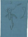
| Date: | 06 1879 |
|---|---|
| Description: | Tracing of a cave petroglyph depicting a human figure wearing headgear. A club is depicted to the right of the figure. |

| Date: | 1828 |
|---|---|
| Description: | Drawing by Increase Lapham showing the geological profile of the land between Utica and Knob Creek, Kentucky at a scale of 1/2 inch to a mile. |

| Date: | 12 22 1830 |
|---|---|
| Description: | Increase Lapham's drawing of the geological profile between the Sandusky plains and Portsmouth, Ohio. |
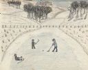
| Date: | 1945 |
|---|---|
| Description: | Three boys play ice hockey on a frozen pond. One boy has fallen and is sitting on the ice. Snow covers the ground, with some grass peeking through. A fence... |
| Date: | 1945 |
|---|---|
| Description: | A threshing scene in a field. One man pitches grain into a threshing machine while standing on the load of grain in the wagon pulled by two horses. A secon... |
| Date: | 1945 |
|---|---|
| Description: | Two boys sled down a snow covered hillside at the farm. Two leafless trees are on the right. Along the horizon is a red building on the left with a fence s... |

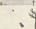
| Date: | 1941 |
|---|---|
| Description: | Elevated view of Sturgeon Bay in 1900. Sturgeon Bay Bridge spans the bay and several boats are on the water. A lighthouse sits on a small island in the bay... |
| Date: | 07 1939 |
|---|---|
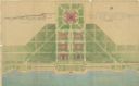
| Description: | An architectural rendering of a proposed lakefront development plan. |
If you didn't find the material you searched for, our Library Reference Staff can help.
Call our reference desk at 608-264-6535 or email us at: