 Filter: Categories of Wisconsin Historical Images
Filter: Subject of Lakes
Filter: Categories of Wisconsin Historical Images
Filter: Subject of Lakes

| Date: | 1960 |
|---|---|
| Description: | Cover for the 1960 Wisconsin Friends of Our Native Landscape program. Depicted are some vibrant purple flowers, with a lake in the background. The Wisconsi... |
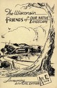
| Date: | 1948 |
|---|---|
| Description: | Cover for the 1948 Wisconsin Friends of Our Native Landscape program. Depicted is a sketch of a tree, a fence, and a small town by a lake. The Wisconsin Fr... |
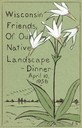
| Date: | 1956 |
|---|---|
| Description: | Cover for the 1956 Wisconsin Friends of Our Native Landscape program. Depicted are some white flowers with green leaves, a lake, and some birds flying in t... |
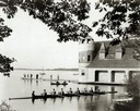
| Date: | |
|---|---|
| Description: | View from shoreline of a crew rowing a Pabst Shell on Lake Mendota near the University of Wisconsin-Madison boathouse, with two men in a canoe and people s... |

| Date: | 07 27 1941 |
|---|---|
| Description: | An elderly man looking blissful, sitting in a boat getting ready to cast his line. |

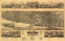
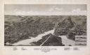
| Date: | 1885 |
|---|---|
| Description: | Bird's-eye map of Oconomowoc. |

| Date: | 1868 |
|---|---|
| Description: | Bird's-eye map of Portage, with insets of the Court House and the Public School. |

| Date: | 1885 |
|---|---|
| Description: | Bird's-eye view of Sheboygan, with inset of J.J. Volrath Manufacturing Company. |

| Date: | 1882 |
|---|---|
| Description: | Bird's-eye map of Lake Geneva, looking southwest, with insets of points of interest. |
| Date: | 1883 |
|---|---|
| Description: | Bird's-eye map of Racine looking south west, with insets of points of interest. |

| Date: | 1867 |
|---|---|
| Description: | Bird's-eye map of Ripon, with insets of points of interest. |

| Date: | 1890 |
|---|---|
| Description: | Bird's-eye view of Superior, Wisconsin. |

| Date: | 1913 |
|---|---|
| Description: | Bird's-eye map of Superior. "The New Steel Center." |

| Date: | 1892 |
|---|---|
| Description: | Color bird's-eye map of Wauwatosa, looking east toward Milwaukee and Lake Michigan. Predominantly green with cream colored roadways, with six land plots ow... |
| Date: | 1885 |
|---|---|
| Description: | Bird's-eye map of Whitewater with insets of points of interest. |

| Date: | 1891 |
|---|---|
| Description: | Bird's-eye view of Eau Claire. |

| Date: | 1879 |
|---|---|
| Description: | Bird's-eye map of Lake Mills. |

| Date: | 1870 |
|---|---|
| Description: | Bird's-eye map of Madison. The Lakeside House resort is in the foreground, which burned in 1877, in what is now Olin Park. |
If you didn't find the material you searched for, our Library Reference Staff can help.
Call our reference desk at 608-264-6535 or email us at:

