 Filter: Categories of Wisconsin Historical Images
Filter: Subject of Lakes
Filter: Year of 2000-Present
Filter: Year of 2000-2009
Filter: Categories of Wisconsin Historical Images
Filter: Subject of Lakes
Filter: Year of 2000-Present
Filter: Year of 2000-2009
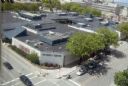
| Date: | 08 2008 |
|---|---|
| Description: | Elevated view of University Square shopping mall between West Johnson Street and University Avenue. (Demolished June 2006). Photograph taken from Witte Hal... |

| Date: | 2003 |
|---|---|
| Description: | The front of map shows trails throughout the bottom half of Wisconsin and includes text on snowmobile rules and tourism contacts. The reverse shows trails ... |

| Date: | 2000 |
|---|---|
| Description: | This map shows Wisconsin Public Service Corporation property, special regulation areas, public boat landings, roads, parks, and other recreation areas. Ins... |

| Date: | 2004 |
|---|---|
| Description: | This map shows ATMs, houses of worship, hotels, parking ramps, public parking, union cab stands, bus stops, business district, parks and public areas, gove... |
If you didn't find the material you searched for, our Library Reference Staff can help.
Call our reference desk at 608-264-6535 or email us at: