 Filter: Categories of Wisconsin Historical Images
Filter: Subject of Lakes
Filter: Year of 2000-Present
Filter: Subject of roads
Filter: Categories of Wisconsin Historical Images
Filter: Subject of Lakes
Filter: Year of 2000-Present
Filter: Subject of roads
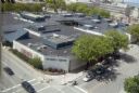
| Date: | 08 2008 |
|---|---|
| Description: | Elevated view of University Square shopping mall between West Johnson Street and University Avenue. (Demolished June 2006). Photograph taken from Witte Hal... |

| Date: | 2013 |
|---|---|
| Description: | Map is the most extensive endeavor to date to accurately locate and document both prehistoric place names and natural features of the Menominee language wi... |

| Date: | 2000 |
|---|---|
| Description: | This map shows Wisconsin Public Service Corporation property, special regulation areas, public boat landings, roads, parks, and other recreation areas. Ins... |

| Date: | 2010 |
|---|---|
| Description: | A man drives a tractor on John Nolen Drive along Lake Mendota with the Wisconsin State Capitol in the distance. He is on his was to a Red Power venue held ... |
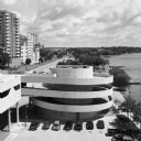
| Date: | 07 2014 |
|---|---|
| Description: | View from the top level of Monona Terrace towards the spiral ramp leading to the outdoor parking lot. Just beyond is John Nolen Drive and railroad tracks. ... |
If you didn't find the material you searched for, our Library Reference Staff can help.
Call our reference desk at 608-264-6535 or email us at: