 Filter: Categories of Wisconsin Historical Images
Filter: Subject of Lakes
Filter: Year of 1900-1999
Filter: Year of 1990-1999
Filter: Categories of Wisconsin Historical Images
Filter: Subject of Lakes
Filter: Year of 1900-1999
Filter: Year of 1990-1999

| Date: | 06 12 1998 |
|---|---|
| Description: | "Barth's Linden Inn is located on the West shore of Big Cedar Lake, between Slinger and West Bend on Hwy. 144." From left to right; Ralph "Buddy" Ruecker, ... |

| Date: | 1994 |
|---|---|
| Description: | This brochure consists of a series of 16 maps of the Military Ridge State Park Trail and the Sugar River State Trail. In all, 62 miles of bike trails and 1... |

| Date: | 1991 |
|---|---|
| Description: | This canoe guide depicts the Wisconsin River from just north of Prairie du Sac to near Spring Green. Landmarks and points of interest are identified and de... |

| Date: | 10 10 1991 |
|---|---|
| Description: | Publicity photograph of the four band members from Poopshovel, a Madison, Wisconsin rock band. From left to right are Rich Whitaker, Bill Crawford, Dave Ko... |

| Date: | 1993 |
|---|---|
| Description: | A series of three maps showing the lands of the Menominee, the first of these three maps shows the present-day Menominee Indian Reservation. Highways and r... |
| Date: | 1991 |
|---|---|
| Description: | A map of Shawano Lake. Lake depths are shown by isolines. "Not intended for navigation." It includes a location map and a list of fish. |

| Date: | 1991 |
|---|---|
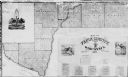
| Description: | This 1991 map of Burnett County, Wisconsin, shows Governor Knowles State Forest, wildlife areas, public hunting grounds, and other outdoor recreation facil... |

| Date: | 1992 |
|---|---|
| Description: | This 1992 map of Wood County, Wisconsin, shows towns, sections, cities and villages, highways and roads, railroads, and lakes and streams. An inset map of ... |

| Date: | 1990 |
|---|---|
| Description: | Map of bike routes in Madison. Lower right corner features a system map with legend. Upper left corner is an inset of the Capital Loop with labelled points... |
| Date: | 1993 |
|---|---|
| Description: | Color photo of a man and a woman assisting a girl on a wheelchair lift for a model 3600 Special Needs bus. The "International" emblem is on the front of th... |

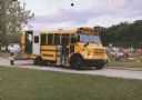
| Date: | 1992 |
|---|---|
| Description: | This guide features a map of suggested bike routes. Also included is a legend, text on how to use the map and legend, points of interest, and safety tips. |

| Date: | 1996 |
|---|---|
| Description: | This map shows roads, lakes, points of interest including colleges, trails, historic communities and sites, museums, and parks. Also included are descripti... |
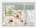
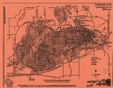
| Date: | 1998 |
|---|---|
| Description: | This map shows the number of Welsh-born heads of households around 1870. A small inset map in the lower left corner shows Welsh land ownership in the heart... |
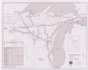
| Date: | 1990 |
|---|---|
| Description: | This map shows Wisconsin Central Ltd. main track, lines out of service, abandoned lines, and trackage rights. The map covers Wisconsin and Michigan's upper... |
| Date: | 1990 |
|---|---|
| Description: | This map shows the town boundaries, Lake Pepin, and landownership in the county. The map includes a business directory, statistics and distances tables, an... |

| Date: | 1991 |
|---|---|
| Description: | This map shows public access, fish crib locations, resorts, and other local businesses as well as advertisements for local attractions and a resort index. ... |
| Date: | 11 1990 |
|---|---|
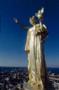
| Description: | Close-up of the statue "Wisconsin," created by Daniel Chester French and situated on top of the dome of the Wisconsin State Capitol, immediately after clea... |

| Date: | 1990 |
|---|---|
| Description: | This map includes two insets: Plat of New Holstein village and Village of Chilton. The map also includes a table of statistics showing the assessed value o... |

| Date: | 1998 |
|---|---|
| Description: | "Party on the Ice" sign outdoors promoting the events that are included in the Lake Winnebago celebration. Events included Sturgeon-Spearing and crowds ass... |
| Date: | 1993 |
|---|---|
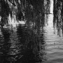
| Description: | The leaves and branches of a willow tree lightly hanging over the surface of a lagoon. |
If you didn't find the material you searched for, our Library Reference Staff can help.
Call our reference desk at 608-264-6535 or email us at: