 Filter: Categories of Wisconsin Historical Images
Filter: Subject of Lakes
Filter: Year of 1900-1999
Filter: Year of 1980-1989
Filter: Categories of Wisconsin Historical Images
Filter: Subject of Lakes
Filter: Year of 1900-1999
Filter: Year of 1980-1989

| Date: | 08 12 1984 |
|---|---|
| Description: | A bikini-clad woman snaps a self-portrait with a long cable release attached to a camera as she is tossed into the air by a group of men on the beach. Othe... |

| Date: | 07 20 1988 |
|---|---|
| Description: | Young men clamor to catch a Frisbee during a beach game. |

| Date: | 08 1980 |
|---|---|
| Description: | Wisconsin State Capitol from the top of the Concourse Hotel. |

| Date: | 10 1981 |
|---|---|
| Description: | Man rowing scull in water in front of silhouette of the Madison skyline including the Wisconsin State Capitol. |
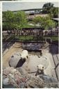
| Date: | 1980 |
|---|---|
| Description: | Elevated view of two polar bears in their enclosure at the Vilas Park Zoo (Henry Vilas Zoo). A crowd is gathered behind the fence, and in the far backgroun... |

| Date: | 1987 |
|---|---|
| Description: | This 1987 map of Door County, Wisconsin, shows streets and roads, cities and villages, state parks, lakes and streams, and depths in Lake Michigan. A stree... |

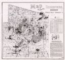
| Date: | 1986 |
|---|---|
| Description: | This late 1980s map of Price County, Wisconsin, shows facilities and lands open for public recreation, hunter walking trails and ski trails, campgrounds, b... |

| Date: | 1987 |
|---|---|
| Description: | This 1987 map of Racine and Kenosha counties, Wisconsin, shows towns, sections, cities and villages, zip code boundaries, highways and roads, bicycle route... |

| Date: | 1982 |
|---|---|
| Description: | Color map. "Topography by photogrammetric methods from aerial photographs taken 1963. Revised from aerial photographs taken 1978. Field checked 1979. Map e... |
| Date: | 1987 |
|---|---|
| Description: | This map shows reservoirs, drainage areas, and parts of of Lincoln, Langlade, Forest, Oneida, and Vilas counties. Includes 1 inset map of corrections for R... |
| Date: | 1987 |
|---|---|
| Description: | This map shows creeks, lakes, ponds, and rivers. Also included are illustrations and a table of trout food, tips on trout fishing and notes on top trout st... |

| Date: | 1982 |
|---|---|
| Description: | This standard U.S.G.S. topographic map was annotated by civil engineer and railroad historian James P. Kaysen to show the location of existing and defunct ... |

| Date: | 1980 |
|---|---|
| Description: | This map shows schools, hotels, stations, roads, railroads, reefs, and public buildings. The upper right corner includes "A Summer and Winter Guide for Spo... |

| Date: | 1988 |
|---|---|
| Description: | A young Governor Thompson sits on a chair in a boat holding a bass in his right hand and a fishing pole in his left. He wears a t-shirt, jeans, and a baseb... |
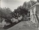
| Date: | 1982 |
|---|---|
| Description: | View across a lawn towards the back of a house. The lawn slopes down to the left towards a tree-lined shore, with a bench and a pier. In the background is ... |
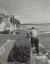
| Date: | 1982 |
|---|---|
| Description: | A man, identified as Edgar Hornung, trims a hedge along a chain link fence. He stands on rocks at the top of the steep shoreline with his back to the camer... |

| Date: | 1982 |
|---|---|
| Description: | Men and women sitting or standing on a sandy beach. A small child is standing on the shoreline in the water. A small group of people is sitting on a grassy... |

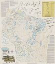
| Date: | 1989 |
|---|---|
| Description: | This color coded map shows the various rivers, lakes, bays, and islands that make up the harbor. It includes an index of industries (maritime and non-marit... |

| Date: | 1985 |
|---|---|
| Description: | This map shows mining, White River, Silver Creek, Bad River, Agogic Lake, Chequamegon Bay, smaller lakes, the Bad River Indian Reservation, and communities... |
If you didn't find the material you searched for, our Library Reference Staff can help.
Call our reference desk at 608-264-6535 or email us at:
