 Filter: Categories of Wisconsin Historical Images
Filter: Subject of Lakes
Filter: Year of 1800-1899
Filter: Year of 1820-1829
Filter: Categories of Wisconsin Historical Images
Filter: Subject of Lakes
Filter: Year of 1800-1899
Filter: Year of 1820-1829

| Date: | 1823 |
|---|---|
| Description: | In 1823 U.S. Army major Stephen H. Long led an expedition of scientific, trade, and military investigation up the Mississippi River and the Red River of th... |
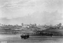
| Date: | 1820 |
|---|---|
| Description: | Engraving of Fort Dearborn (center) and Kinzie Mansion (right) after Seth Eastman's original drawing in 1820 for the U. S. Army. Several people are visible... |

| Date: | 1824 |
|---|---|
| Description: | Drawn and engraved by Sidney Hall. Published by Longman, Hurst, Rees, Orme, Brown & Green. Scale: 1:200. Partly colored. This is probably the second Europe... |

| Date: | 1820 |
|---|---|
| Description: | Map of the Northwestern Territories of the United State showing the track pursued by the Expedition in 1820. |
| Date: | 1820 |
|---|---|
| Description: | Narrative Journal of Travels through the northwestern regions of the United States, extending from Detroit through the great chain of American lakes to the... |

| Date: | 1829 |
|---|---|
| Description: | This map shows waterways, trails, settlements, Indian villages, and boundaries. The map includes text in the lower left with excerpts from Indian land trea... |
If you didn't find the material you searched for, our Library Reference Staff can help.
Call our reference desk at 608-264-6535 or email us at: