 Filter: Categories of Wisconsin Historical Images
Filter: Subject of Lakes
Filter: Year of 1800-1899
Filter: Year of 1880-1889
Filter: County of Milwaukee
Filter: Categories of Wisconsin Historical Images
Filter: Subject of Lakes
Filter: Year of 1800-1899
Filter: Year of 1880-1889
Filter: County of Milwaukee
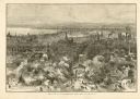
| Date: | 1882 |
|---|---|
| Description: | Bird's-eye view of Milwaukee looking south down 8th Street from Schlitz's Park. |

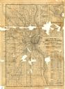
| Date: | 1882 |
|---|---|
| Description: | This basic reference map of the state shows natural features, railroads, county seats, and political boundaries against the G.L.O. township and range grid.... |
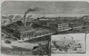
| Date: | 1883 |
|---|---|
| Description: | Etched print of factory with inset of Bay State Works in lower right corner. Lake with ships in background, with busy, buggy covered roads in foreground. ... |

| Date: | 1886 |
|---|---|
| Description: | A hand-colored map of Milwaukee County, Wisconsin that shows the township and range system, sections, towns, roads, railroads and rail stations, cities and... |

| Date: | 1880 |
|---|---|
| Description: | Map created from original drawing and surveys taken by Silas Chapman. Bottom right corner features a reference key. There is a street guide on the left sid... |
| Date: | 1886 |
|---|---|
| Description: | Two maps on one page. The first page is a map of Milwaukee County with insets "Plan of Pewaukee, Waukesha Co.," "Plan of Oconomowoc, Waukesha Co.," "Plan o... |

| Date: | 1880 |
|---|---|
| Description: | This map shows wards, roads, railroads, lot and block numbers, subdivisions, parks, and some landownership. A handwritten annotation in red reads: "Note: S... |
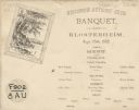
| Date: | 1882 |
|---|---|
| Description: | Card menu for the Wisconsin Authors' Club Banquet at Klosterheim. On the top left is a framed landscape of trees overlooking a body of water. |
If you didn't find the material you searched for, our Library Reference Staff can help.
Call our reference desk at 608-264-6535 or email us at: