 Filter: Categories of Wisconsin Historical Images
Filter: Subject of Lakes
Filter: Year of 1800-1899
Filter: Year of 1870-1879
Filter: Year of 1875
Filter: Categories of Wisconsin Historical Images
Filter: Subject of Lakes
Filter: Year of 1800-1899
Filter: Year of 1870-1879
Filter: Year of 1875

| Date: | 1875 |
|---|---|
| Description: | Elevated view of people, elegantly dressed, posing on a pier, with a steamboat and rowboats docked on it on Devil's Lake. An American flag is on the steamb... |
| Date: | 1875 |
|---|---|
| Description: | Lake Mendota shore looking west with A.L. Dahl's photographer's wagon on shore and the Wisconsin State Capitol visible in the background. |
| Date: | 1875 |
|---|---|
| Description: | View from Southeast shore of Lake Monona across a cornfield, perhaps on the farm of Thomas Williamson. |
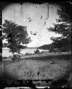
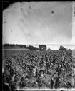
| Date: | 1875 |
|---|---|
| Description: | Members of the Chicago Traveling Club are encamped on the shores of Lake Mendota and are posed with their tents, guns, cooking equipment, boat, paddles, sh... |
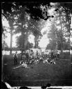
| Date: | 1875 |
|---|---|
| Description: | A large group of well-dressed people are standing aboard three small steamboats on Lake Monona. The boat in the foreground is a barge with a sternwheel. Th... |

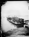
| Date: | 07 1875 |
|---|---|
| Description: | Chicago Traveling Club encamped at McBride's Point at Maple Bluff on Lake Mendota near Madison. An African American sits at the left foreground with pans ... |

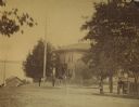
| Date: | 1875 |
|---|---|
| Description: | View of the Capitol Square from the roof of the Wisconsin State Capitol, looking south. The view includes the Park Hotel, The Baptist Church and St. Raphae... |
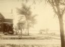
| Date: | 1875 |
|---|---|
| Description: | Exterior view of the Giles house, residence of Hiram H. Giles, state legislator and social welfare authority. |
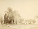
| Date: | 1875 |
|---|---|
| Description: | The Giles house, residence of Hiram H. Giles, state legislator and social welfare authority. |

| Date: | 1875 |
|---|---|
| Description: | Exterior view of the Giles house, residence of Hiram H. Giles, state legislator and social welfare authority. |
| Date: | 1875 |
|---|---|
| Description: | View of the Spooner residence on the south corner of Wilson and Carroll Streets, with the lake in the background. This was the home of John C., Phil H., an... |

| Date: | 1875 |
|---|---|
| Description: | A full circle panorama as it would be seen from the top of the Wisconsin State Capitol. This painting was based on photographs perhaps taken by Edward Niel... |

| Date: | 1875 |
|---|---|
| Description: | Map of the triangulations made from Vulcan on the Keweenaw Peninsula in the Upper Peninsula of Michigan south through eastern Wisconsin, past Chicago to Ba... |

| Date: | 1875 |
|---|---|
| Description: | A hand-drawn and colored map of Wisconsin showing the railroad routs and railroad land grants La Cross and Milwaukee Railroad, St. Croix and Tomah Railroad... |

| Date: | 1875 |
|---|---|
| Description: | This hand-colored map of Wisconsin and the western portion of Michigan's Upper Peninsula depicts the township survey grid and identifies counties, named to... |

| Date: | 1875 |
|---|---|
| Description: | This manuscript map by Increase Lapham, drawn in the last year of his life, shows landownership, roads and railroads, springs, and boat houses around Ocono... |

| Date: | 06 1875 |
|---|---|
| Description: | These manuscript drawings show the profile of the Neenah Dam, between Lake Winnebago and Little Lake Butte des Morts on the Fox River in Winnebago County, ... |

| Date: | 1875 |
|---|---|
| Description: | This map, from G.K. Warren's 1876 Report on the transportation route along the Wisconsin and Fox rivers in the State of Wisconsin between the Mississippi R... |

| Date: | 1875 |
|---|---|
| Description: | Shows land ownership by name, local streets, buildings, cemeteries, Chippewa River, and Half Moon Lake. Includes 1 inset map of Eau Claire. Also includes c... |

| Date: | 1875 |
|---|---|
| Description: | This map shows Chicago Mil. & St. Paul R.R., Chicago & N.W. R.R., Wisconsin Central R.R., and other railroads. Eastern Minnesota, the upper peninsula of Mi... |
If you didn't find the material you searched for, our Library Reference Staff can help.
Call our reference desk at 608-264-6535 or email us at: