Filter: Categories of Wisconsin Historical Images
Filter: Subject of Lakes
Filter: Year of 1800-1899
Filter: Year of 1870-1879
Filter: Categories of Wisconsin Historical Images
Filter: Subject of Lakes
Filter: Year of 1800-1899
Filter: Year of 1870-1879

| Date: | 1871 |
|---|---|
| Description: | A map of California showing railroad lines and reservations. |

| Date: | 1873 |
|---|---|
| Description: | This blueprint map shows water depths by soundings and isolines. To the top left is Duluth, Minnesota. To the bottom right is Superior City, Wisconsin. The... |
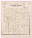
| Date: | 1873 |
|---|---|
| Description: | A plat map of the town of Pleasant Springs. |
If you didn't find the material you searched for, our Library Reference Staff can help.
Call our reference desk at 608-264-6535 or email us at: