 Filter: Categories of Wisconsin Historical Images
Filter: Subject of Lakes
Filter: Year of 1800-1899
Filter: Subject of transportation
Filter: Categories of Wisconsin Historical Images
Filter: Subject of Lakes
Filter: Year of 1800-1899
Filter: Subject of transportation
| Date: | 1896 |
|---|---|
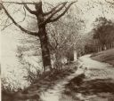
| Description: | Looking down University of Wisconsin Drive (present-day Lakeshore Path). Large trees grows along the shoreline on the left, and on the right is a thick woo... |

| Date: | 1896 |
|---|---|
| Description: | Mrs. Elsie Stevens poses on a path by a lake while riding a horse. Possibly on the University of Wisconsin-Madison drive (present-day Lakeshore path). |
| Date: | 1894 |
|---|---|
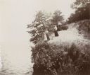
| Description: | Elevated view of three women and a young girl standing at the edge of a small cliff on the shores of Lake Mendota. Various shrubs and small trees grow on t... |

| Date: | 1855 |
|---|---|
| Description: | Map of Milwaukee, Waukesha, Racine, and Kenosha Counties with part of Walworth County showing townships, waterways, railroads, plank roads, prairies, meado... |

| Date: | 1882 |
|---|---|
| Description: | The official railroad map of Wisconsin showing railroad lines throughout the state. |

| Date: | 1884 |
|---|---|
| Description: | The official railroad map of Wisconsin showing railroad lines throughout the state. |
| Date: | 1898 |
|---|---|
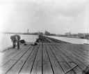
| Description: | Fishermen fishing off of a long pier. Industrial buildings are across the water in the background. |
| Date: | 07 1899 |
|---|---|
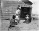
| Description: | Syl with two women and a man, all wearing hats, fishing off of a dock in Sturgeon Bay. Behind them is a small wooden structure. |

| Date: | 1896 |
|---|---|
| Description: | Section 2 of 12, this bicycle road map features Wisconsin bicycle routes in the counties of Marquette, Green Lake, Columbia, Fond Du Lac, Dodge, Washington... |

| Date: | 1896 |
|---|---|
| Description: | Section 5 of 12, this bicycle road map features Wisconsin bicycle routes in the counties of La Crosse, Monroe, Vernon, Crawford, Richland, Sauk, Juneau, an... |
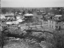
| Date: | 07 07 1898 |
|---|---|
| Description: | View across water of Sturgeon Bay. In the far distance are lighthouses, buildings, and barges along the shoreline. |
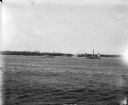
| Date: | 06 12 1899 |
|---|---|
| Description: | View over water, perhaps Hatfield Lake, of houses damaged and demolished in a tornado. Floating at the edge of the lake near an eroded bank are numerous pi... |

| Date: | 1896 |
|---|---|
| Description: | A map of the Chain-O-Lakes in Waupaca, including Indian trails. The path of the Waupaca Electric Railway from the Grand View Hotel to the Wisconsin Central... |
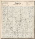
| Date: | 1873 |
|---|---|
| Description: | A map of Verona Township from the Dane County Atlas. |

| Date: | 1884 |
|---|---|
| Description: | Cover art for a pamphlet advertising The Apostle Islands and Lake Superior. The upper half of the artwork depicts a sunset view of Lake Superior, and the b... |

| Date: | 1877 |
|---|---|
| Description: | Map of northern Wisconsin showing the lands owned by Cornell University (shaded portions) in 1877. The map depicts the lakes, river systems, towns, and th... |

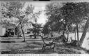
| Date: | 1870 |
|---|---|
| Description: | View of two lakeside cottage, which have docks and porches that overlook the lake. Caption reads: "Birch Walk, Kelly Lake, Wis." |
| Date: | 1870 |
|---|---|
| Description: | View toward three cottages along the tree-lined shore of Kelly Lake at Underwood Point. Small docks with boats are along the shoreline. A wooden bench with... |

| Date: | 1870 |
|---|---|
| Description: | Stereograph of a lake scene in Madison, probably looking south on Lake Monona at a boat race in progress. From the series "The Beauties of the City of Madi... |
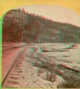
| Date: | 1874 |
|---|---|
| Description: | A yellow mount stereograph of the railroad tracks skirting the edge of Devil's Lake, with several boats tied up alongside. From the stereograph series "The... |
If you didn't find the material you searched for, our Library Reference Staff can help.
Call our reference desk at 608-264-6535 or email us at: