 Filter: Categories of Wisconsin Historical Images
Filter: Subject of Lakes
Filter: Year of 1800-1899
Filter: Subject of learning and scholarship
Filter: Categories of Wisconsin Historical Images
Filter: Subject of Lakes
Filter: Year of 1800-1899
Filter: Subject of learning and scholarship

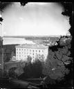
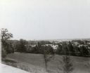
| Date: | 1897 |
|---|---|
| Description: | A view from the capitol looking west up State Street toward the University of Wisconsin-Madison with the Holy Redeemer Church, Holy Redeemer School, Red Gy... |

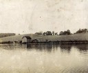
| Date: | 1852 |
|---|---|
| Description: | Pencil drawing of Madison landscape as seen from University Hill. The main street in the center is State Street, and the building with Greek columns in the... |
| Date: | 1888 |
|---|---|
| Description: | View of shoreline along Picnic Point on the University of Wisconsin-Madison campus showing the home of Professor William Daniels, head of the Chemistry Dep... |
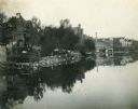
| Date: | 1876 |
|---|---|
| Description: | View from Main Hall (later Bascom Hall) on the University of Wisconsin campus. North Hall is in the foreground. Behind it is Langdon Street and, in the d... |
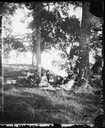
| Date: | 1877 |
|---|---|
| Description: | A group, probably at Picnic Point on Lake Mendota in Madison, posed under the trees. Picnic baskets are behind them. Mrs. Bashford is the person in Mrs. ... |
| Date: | 1887 |
|---|---|
| Description: | Picnic Point from University Drive. |
| Date: | 1898 |
|---|---|
| Description: | View across water towards the Lake Mendota shoreline from the foot of Frances Street. |
| Date: | 06 26 1896 |
|---|---|
| Description: | View of Lake Monona from Observatory Hill, on the University of Wisconsin campus. Building are below the hill among trees. |

| Date: | 1892 |
|---|---|
| Description: | Looking east down Langdon Street from Science Hall. In the distance is the Wisconsin State Capitol. Lake Mendota is on the left. |

| Date: | 1888 |
|---|---|
| Description: | View of Picnic Point stretching out into Lake Mendota on the University of Wisconsin-Madison campus. |
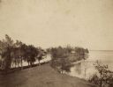
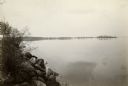
| Date: | 1888 |
|---|---|
| Description: | View of Picnic Point on the University of Wisconsin-Madison campus. The peninsula juts into Lake Mendota. The far shoreline can be seen in the distance. |

| Date: | 11 24 1898 |
|---|---|
| Description: | Elevated view from the top of Main Hall (later Bascom Hall) of Picnic Point on Lake Mendota from the University of Wisconsin-Madison campus. |

| Date: | 04 1896 |
|---|---|
| Description: | View from Chi Psi porch on the University of Wisconsin-Madison campus. Picnic Point is stretching towards the right in the far background. There appears to... |
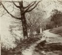
| Date: | 1896 |
|---|---|
| Description: | Looking down University of Wisconsin Drive (present-day Lakeshore Path). Large trees grows along the shoreline on the left, and on the right is a thick woo... |

| Date: | 1896 |
|---|---|
| Description: | Mrs. Elsie Stevens poses on a path by a lake while riding a horse. Possibly on the University of Wisconsin-Madison drive (present-day Lakeshore path). |

| Date: | 1877 |
|---|---|
| Description: | Map of northern Wisconsin showing the lands owned by Cornell University (shaded portions) in 1877. The map depicts the lakes, river systems, towns, and th... |

| Date: | 1877 |
|---|---|
| Description: | This map shows the lands in northern Wisconsin owned by Cornell University that were for sale. Text on the map encourages interested buyers to seek more in... |

| Date: | 1842 |
|---|---|
| Description: | This map shows portions of northern Illinois and Wisconsin surveyed by the map's creation. It shows county lines and university land, and depicts lead and ... |

| Date: | 05 1846 |
|---|---|
| Description: | Hand-colored map of southeastern Wisconsin showing the counties of Dodge, Jefferson, Rock, Walworth, Racine (including modern-day Kenosha County), Waukesha... |
If you didn't find the material you searched for, our Library Reference Staff can help.
Call our reference desk at 608-264-6535 or email us at:
