 Filter: Categories of Wisconsin Historical Images
Filter: Subject of Lakes
Filter: Year of 1800-1899
Filter: Subject of cities and towns
Filter: Creator Name of Unknown
Filter: Categories of Wisconsin Historical Images
Filter: Subject of Lakes
Filter: Year of 1800-1899
Filter: Subject of cities and towns
Filter: Creator Name of Unknown
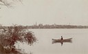
| Date: | 1894 |
|---|---|
| Description: | Man in a rowboat on Lake Monona with a view of the city in the background. |

| Date: | 1884 |
|---|---|
| Description: | A sign for Fauerbach's Brewery depicting a young woman and the brewery. |

| Date: | 1873 |
|---|---|
| Description: | Map of the township of Windsor, from the "Atlas of Dane County." |

| Date: | 1873 |
|---|---|
| Description: | Newspaper reproduction of an etching of the Milwaukee River. |

| Date: | 1861 |
|---|---|
| Description: | Drawn the first year of the Civil War, this colored 1861 map of Dane County shows its towns, cities and lakes. It includes insets of the wards of Madison a... |

| Date: | 1876 |
|---|---|
| Description: | Bird's-eye view of Black Earth. |

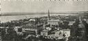
| Date: | 1897 |
|---|---|
| Description: | A view from the capitol looking west up State Street toward the University of Wisconsin-Madison with the Holy Redeemer Church, Holy Redeemer School, Red Gy... |

| Date: | 1836 |
|---|---|
| Description: | The top map is the "Plat of Madison the Capitol of Wisconsin." The bottom map is the "Map of the Four Lake Country. Taken from the Township Maps in the U.S... |

| Date: | 1870 |
|---|---|
| Description: | Bird's-eye map of Madison. The Lakeside House resort is in the foreground, which burned in 1877, in what is now Olin Park. |

| Date: | 1868 |
|---|---|
| Description: | Bird's-eye map of Manitowoc, with four insets. Manitowoc County. |
| Date: | 1873 |
|---|---|
| Description: | Elevated view of South Pinckney Street from the Wisconsin State Capitol, with East Washington Avenue to the left and Lake Monona on the distant right. The ... |
| Date: | 1895 |
|---|---|
| Description: | Elevated view of Lake Geneva with the Lake Geneva steamboat. |
| Date: | 1887 |
|---|---|
| Description: | Picnic Point from University Drive. |
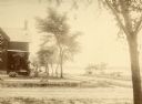
| Date: | 1855 |
|---|---|
| Description: | Early view of the house built by Madison's first mayor, Jairus C. Fairchild, at 302 South Wisconsin Avenue (renamed Monona Avenue in 1877) at West Wilson S... |
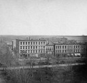
| Date: | 1890 |
|---|---|
| Description: | The First Baptist Church, pictured in the lower center area of the photograph, organized in 1847 and erected in 1854. St. Raphael's Cathedral in the backgr... |

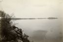
| Date: | 1856 |
|---|---|
| Description: | Isthmus of Madison, including Lake Mendota, or Great Lake, and Lake Menona [sic]. |

| Date: | 1877 |
|---|---|
| Description: | Map showing location of Indian reservations in the United States and population figures. |
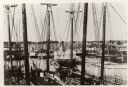
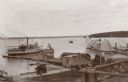
| Date: | 1887 |
|---|---|
| Description: | Some of the Old-Timers in the photograph: Steamers: Petosky (on stocks), Muskegon, Corona, A.D. Hayward, City of St. Joe, Lotus, J.F. Dayan, Grace Willia... |
| Date: | 1875 |
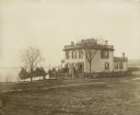
|---|---|
| Description: | Exterior view of the Giles house, residence of Hiram H. Giles, state legislator and social welfare authority. |
If you didn't find the material you searched for, our Library Reference Staff can help.
Call our reference desk at 608-264-6535 or email us at:
