 Filter: Categories of Wisconsin Historical Images
Filter: Subject of Lakes
Filter: Year of 1800-1899
Filter: County of Green Lake
Filter: Categories of Wisconsin Historical Images
Filter: Subject of Lakes
Filter: Year of 1800-1899
Filter: County of Green Lake
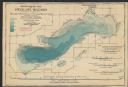
| Date: | 1898 |
|---|---|
| Description: | A hydrographic map of Green Lake, Geneva, Wisconsin, and includes 5 cross sections of the depths at various points as well as along a line running the leng... |

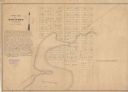
| Date: | 1896 |
|---|---|
| Description: | A map of Green Lake County, Wisconsin, shows township divisions, villages and post offices, railroads, roads, lakes and streams, schools, and churches. |
| Date: | 1849 |
|---|---|
| Description: | The map reads: "Dartford is centrally located in Wisconsin, on the north side of Green Lake, and in full view of that beautiful sheet of Water. Its precise... |
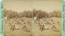
| Date: | 1885 |
|---|---|
| Description: | Scattered figures of a picnic party on a grassy slope. |

| Date: | 1860 |
|---|---|
| Description: | This map shows roads, railroads, rivers, townships, school houses, churches, cemeteries, and land ownership by name. Relief is shown by hachures. The map i... |
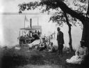
| Date: | 1895 |
|---|---|
| Description: | View towards shoreline with several people on or near a docked boat next to a pier. An African-American woman is sitting under a tree with a white baby on ... |

| Date: | 1857 |
|---|---|
| Description: | Green Lake County Abstract plat map, T. 14 N, R. 11 E. |

| Date: | 1857 |
|---|---|
| Description: | Green Lake County plat map, T. 15 N., R. 12 E. |

| Date: | 1857 |
|---|---|
| Description: | Green Lake County plat map, T. 14 N, R. 12 E. |

| Date: | 1857 |
|---|---|
| Description: | Green Lake County plat map, T. 16 N, R. 12 E. |

| Date: | 1857 |
|---|---|
| Description: | Green Lake County plat map, T. 14 N, R. 13 E. |

| Date: | 1857 |
|---|---|
| Description: | Green Lake County plat map, T. 15 N, R. 13 E. |

| Date: | 1857 |
|---|---|
| Description: | Green Lake County plat map, T. 16 N, R. |
If you didn't find the material you searched for, our Library Reference Staff can help.
Call our reference desk at 608-264-6535 or email us at: