 Filter: Categories of Wisconsin Historical Images
Filter: Subject of Lakes
Filter: Subject of transportation
Filter: Categories of Wisconsin Historical Images
Filter: Subject of Lakes
Filter: Subject of transportation

| Date: | 1823 |
|---|---|
| Description: | In 1823 U.S. Army major Stephen H. Long led an expedition of scientific, trade, and military investigation up the Mississippi River and the Red River of th... |

| Date: | 1908 |
|---|---|
| Description: | Colored map showing a panoramic view of Madison in great detail. The Wisconsin State Capitol is located at the center, with Lake Mendota in the background ... |
| Date: | 1917 |
|---|---|
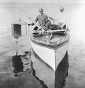
| Description: | Edward A. Birge and Chancey Juday with plankton trap in Lake Mendota. From album of photographs relating to the research in limnology conducted at Trout La... |
| Date: | 1900 |
|---|---|
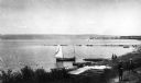
| Description: | Elevated view of La Pointe and the shoreline from the Old Mission dock. Two boys and two men stand along the shoreline. The white building with the dark ro... |

| Date: | 1950 |
|---|---|
| Description: | Aerial view of the Wisconsin State Capitol building and surrounding Madison area. Lake Monona is in the background. |

| Date: | 1884 |
|---|---|
| Description: | A sign for Fauerbach's Brewery depicting a young woman and the brewery. |
| Date: | 1890 |
|---|---|
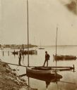
| Description: | Two men pose on a boat docked at the Askew Steamboat Landing on Lake Monona off South Carroll Street. The old Governor Harvey residence is in the backgroun... |
| Date: | 1915 |
|---|---|
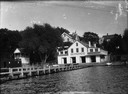
| Description: | View from water of Bernard's Boat House on Lake Mendota, adjacent to the present James Madison Park. |
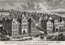
| Date: | 1887 |
|---|---|
| Description: | Engraving of an elevated view of Science Hall, Chemical Laboratory and Machine Shop on the University of Wisconsin-Madison campus. |

| Date: | 1856 |
|---|---|
| Description: | This map show the surveyed southern part of state and includes "profile of the Milwaukee and Mississippi Rail Road." Counties are shown in pink, green, blu... |

| Date: | 1886 |
|---|---|
| Description: | This map shows U.S. land offices, completed railroads, railroad land grant limits, lakes, rivers, and Indian reservations. Communities, lakes, and rivers a... |

| Date: | 06 1837 |
|---|---|
| Description: | Lithograph based on a painting by Mrs. E.E. Bailey showing the Peck cabin, the first house in Madison. In addition to the cabin, the lithograph includes a ... |

| Date: | 1835 |
|---|---|
| Description: | Little Lake Butte Des Morts just north of Lake Winnebago where Governor Lewis Cass of Michigan, and Thomas McKenney, head of the Bureau of Indian Affairs (... |

| Date: | 1874 |
|---|---|
| Description: | This map shows lakes, rivers, state, county, and town boundaries, as well as railroads completed, in progress, and contemplated. The map includes a color d... |
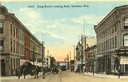
| Date: | 1910 |
|---|---|
| Description: | Colorized view of King Street, looking east, with a streetcar. Lake Monona is in the background. Caption reads: "King Street, looking East, Madison, Wis." |

| Date: | 1908 |
|---|---|
| Description: | A panoramic aerial view of the Isthmus taken from a kite. Lake Mendota is to the right in the background with Picnic Point jutting into the lake. The photo... |
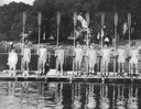
| Date: | 05 26 1931 |
|---|---|
| Description: | University of Wisconsin-Madison crew team holding their long oars, with coxswain on a pier on Lake Mendota. |
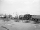
| Date: | 04 24 1931 |
|---|---|
| Description: | Boathouses on Lake Monona looking southeast from E. Wilson Street across CNW railroad tracks. View of Wirka Boat Line, E. Wilson Street at S. Hancock Stree... |

| Date: | 06 07 1954 |
|---|---|
| Description: | Aerial view looking north from near the city's southwestern limits in 1954. Shows text indicating Midvale Boulevard, Odana Road, Tokay Boulevard, Mineral P... |

| Date: | 1850 |
|---|---|
| Description: | Elevated view of the Lake Superior shoreline, with terraces leading to the beach. A canoe is on the shoreline. |
If you didn't find the material you searched for, our Library Reference Staff can help.
Call our reference desk at 608-264-6535 or email us at: