 Filter: Categories of Wisconsin Historical Images
Filter: Subject of Lakes
Filter: Subject of service stations
Filter: Categories of Wisconsin Historical Images
Filter: Subject of Lakes
Filter: Subject of service stations
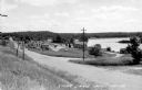
| Date: | 1948 |
|---|---|
| Description: | View from left side of road towards several buildings and a lake on the right. Down the road automobiles are parked outside of a building with a sign that ... |
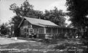
| Date: | 1941 |
|---|---|
| Description: | Exterior view toward the store. There are two gas pumps in front, and trees and a lake in the background. Caption reads: "Log cabin store at Pine Grove Res... |
| Date: | 1937 |
|---|---|
| Description: | Gas pump and automobile next to a tavern on county Road D near Clam Lake. |

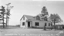
| Date: | |
|---|---|
| Description: | View from across street of Dillman's Sunoco service located at 421 Park Street. |

| Date: | 1930 |
|---|---|
| Description: | This map features a legend of highways, railroads, parks, and service stations. The cover and inside of the map features pictures of attractions in Madison... |

| Date: | 1930 |
|---|---|
| Description: | This map shows county boundaries, roads, cities, highways, points of interest, and the locations of Standard Oil Company Service Stations. Included are por... |

| Date: | 1935 |
|---|---|
| Description: | This map is presented by Conoco, and shows the major roads, cities, lakes, and rivers, as well as some of the neighboring states. It includes an index, sca... |
If you didn't find the material you searched for, our Library Reference Staff can help.
Call our reference desk at 608-264-6535 or email us at: