 Filter: Categories of Wisconsin Historical Images
Filter: Subject of Lakes
Filter: Subject of school buildings
Filter: Categories of Wisconsin Historical Images
Filter: Subject of Lakes
Filter: Subject of school buildings
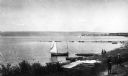
| Date: | 1900 |
|---|---|
| Description: | Elevated view of La Pointe and the shoreline from the Old Mission dock. Two boys and two men stand along the shoreline. The white building with the dark ro... |

| Date: | 1870 |
|---|---|
| Description: | Bird's-eye map of Hudson, with insets of Court House and Public School. |

| Date: | 1868 |
|---|---|
| Description: | Bird's-eye map of Portage, with insets of the Court House and the Public School. |

| Date: | 1930 |
|---|---|
| Description: | Aerial view of near west side, including West High School, the Forest Products Laboratory, Lake Mendota, and Picnic Point. |

| Date: | 1874 |
|---|---|
| Description: | View of the University of Wisconsin-Madison from the Wisconsin State Capitol. |

| Date: | 1905 |
|---|---|
| Description: | Clockwise from upper left images include: Cutters Point, Long Lake, Wis.; M.E. Church, New Auburn, Wis.; Farmers Store, New Auburn, Wis.; Public School, Ne... |
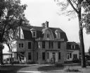
| Date: | 10 08 1947 |
|---|---|
| Description: | Exterior view of Norbertine Novitiate, 4123 Monona Drive. Originally the Frank Allis home built in 1893-94. Lake Monona is in the background. |

| Date: | 02 06 1948 |
|---|---|
| Description: | Looking east along Regent Street with snow on the ground. Visible are Lake Wingra, Monona Bay, railroad causeway across Monona, Lake Mendota, Hoyt Park, We... |
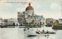
| Date: | |
|---|---|
| Description: | St. Josephat Church and School from Kosciuszko Park. The classic style church with dome is across a body of water. Three boats with boaters are out rowing ... |

| Date: | 1912 |
|---|---|
| Description: | Church and school seen from Kosciuszko Park. Located across a lake, behind some trees and bushes. A woman is sitting on some decorative stones next to the ... |

| Date: | 1900 |
|---|---|
| Description: | Perspective drawing of the buildings at the Hayward Indian School. There is a man in a boat in the right foreground and an empty boat in the left foregroun... |

| Date: | 1925 |
|---|---|
| Description: | This 1925 map of Ashland County, Wisconsin, shows the township and range system, towns, sections, cities and villages, the Bad River Indian Reservation, ra... |

| Date: | 1890 |
|---|---|
| Description: | This map shows the Wisconsin Central Railroad land grant lands owned and for sale by the Soo Line in Ashland County, Wisconsin, as well as in portions of B... |

| Date: | 1890 |
|---|---|
| Description: | This 1890s map shows the Wisconsin Central Railroad land grant lands owned and for sale by the Soo Line in Ashland County, Wisconsin, as well as in the eas... |

| Date: | 1904 |
|---|---|
| Description: | This 1904 map of Dane County, Wisconsin, shows postal routes, post office locations, towns, sections, cities and villages, roads, railroads, collection box... |

| Date: | 1889 |
|---|---|
| Description: | This 1889 map of Douglas County, Wisconsin, shows the township and range grid, towns, sections, cities and villages, roads, existing and proposed railroads... |

| Date: | 1914 |
|---|---|
| Description: | This 1914 map of Douglas County, Wisconsin, shows the township and range grid, towns, sections, cities and villages, roads, railroads, Indian trails, schoo... |

| Date: | 1891 |
|---|---|
| Description: | This late 19th century map shows the lake region around Oconomowoc in Waukesha County and eastern Jefferson County, Wisconsin. The township and range grid,... |

| Date: | 1876 |
|---|---|
| Description: | This late 19th century map by Increase Lapham shows the lake region around Oconomowoc in Waukesha County and eastern Jefferson County, Wisconsin. Cities an... |

| Date: | 1887 |
|---|---|
| Description: | This late 19th century map shows the lake region around Oconomowoc in Waukesha County and eastern Jefferson County, Wisconsin. Cities and villages, roads, ... |
If you didn't find the material you searched for, our Library Reference Staff can help.
Call our reference desk at 608-264-6535 or email us at: