 Filter: Categories of Wisconsin Historical Images
Filter: Subject of Lakes
Filter: Subject of portraits
Filter: Categories of Wisconsin Historical Images
Filter: Subject of Lakes
Filter: Subject of portraits
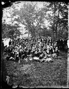
| Date: | 1877 |
|---|---|
| Description: | A large well-dressed group of men and women, with a scattering of children, posed outdoors near a lake. This group portrait may be at Maple Bluff on Lake M... |

| Date: | 1979 |
|---|---|
| Description: | A map of Southern Wisconsin and northern Illinois showing the areas inhabited by the Ho-Chuck, formerly known as the Winnebago. Some of the location names ... |

| Date: | |
|---|---|
| Description: | This 1907 map of Outagamie County, Wisconsin, shows the township and range grid, towns, sections, cities and villages, railroads, wagon roads, churches, sc... |

| Date: | 1860 |
|---|---|
| Description: | This map of Dodge County, Wisconsin, shows the township and range grid, towns, sections, cities and villages, railroads, roads, property owners and acreage... |
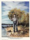
| Date: | 1986 |
|---|---|
| Description: | Painting of a woman standing on a beach and holding a spear point in her hand. In the sand near her is a spear, several arrowheads, and a bag. She is weari... |
If you didn't find the material you searched for, our Library Reference Staff can help.
Call our reference desk at 608-264-6535 or email us at: