 Filter: Categories of Wisconsin Historical Images
Filter: Subject of Lakes
Filter: Subject of orchards
Filter: Categories of Wisconsin Historical Images
Filter: Subject of Lakes
Filter: Subject of orchards
| Date: | |
|---|---|
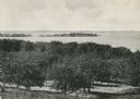
| Description: | Picnic Point from University drive, currently known as Observatory Hill. There are orchards in the foreground. |

| Date: | 1930 |
|---|---|
| Description: | Aerial view over northern Door County, looking northeast across Europe Lake and Europe Bay toward Plum and Washington Islands. Farm fields and orchards con... |

| Date: | 1915 |
|---|---|
| Description: | This map of Door County, Wisconsin, from the early 20th century shows roads, schools, churches, creameries and cheese factories, orchards, docks, quarries,... |

| Date: | 1871 |
|---|---|
| Description: | This map shows buildings, roads, the railroad, an orchard, and swamp land. Relief shown by hachures. The map includes an index of buildings in the upper ri... |
If you didn't find the material you searched for, our Library Reference Staff can help.
Call our reference desk at 608-264-6535 or email us at: