 Filter: Categories of Wisconsin Historical Images
Filter: Subject of Lakes
Filter: Subject of missions
Filter: Categories of Wisconsin Historical Images
Filter: Subject of Lakes
Filter: Subject of missions
| Date: | 1905 |
|---|---|
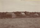
| Description: | View across water towards Old Mission, as seen from the pier with Old Mission Congregational Church behind it. This Mission was established in 1830 by Fred... |
| Date: | 1910 |
|---|---|
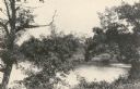
| Description: | View from pier towards the Old Mission in La Pointe on Madeline Island. Men are sitting at the shoreline. Caption reads: "Apostle Islands, Wis. Madeline Is... |
| Date: | 1915 |
|---|---|
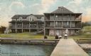
| Description: | Nashotah Mission, Lewis Hall. View from a distance with lake in foreground and mission in background. |

| Date: | 1939 |
|---|---|
| Description: | This map shows the towns to Gingles, Sanborn, and Guney as well as Chequamegon Bay, Kakagon River, White River, Marengo River, Bad River, Potato River, Vau... |

| Date: | 1845 |
|---|---|
| Description: | This map shows lakes, rivers, Chippewa land, the U.S. Mineral Land Agency, boundary between U.S. and Canada, Methodist and Catholic missions, and American ... |

| Date: | 1954 |
|---|---|
| Description: | This map shows the location of Catholic churches, missions, and shrines. The map is color coded and includes a key in the bottom left corner. The back of t... |

| Date: | 1719 |
|---|---|
| Description: | Map of the Great Lakes and the St. Lawrence river showing French and English cities and villages, trading posts, Indian villages and tribes, portages, for... |
If you didn't find the material you searched for, our Library Reference Staff can help.
Call our reference desk at 608-264-6535 or email us at: