 Filter: Categories of Wisconsin Historical Images
Filter: Subject of Lakes
Filter: Subject of madeline island (wis.)
Filter: Categories of Wisconsin Historical Images
Filter: Subject of Lakes
Filter: Subject of madeline island (wis.)
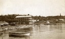
| Date: | 1890 |
|---|---|
| Description: | Old Mission Inn and boats on shoreline of Lake Superior on Madeline Island. The Old Mission Inn had numerous modifications over the years. It was razed in... |
| Date: | 1905 |
|---|---|
| Description: | View across water towards Old Mission, as seen from the pier with Old Mission Congregational Church behind it. This Mission was established in 1830 by Fred... |
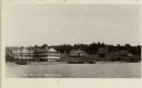
| Date: | 1930 |
|---|---|
| Description: | The Mission Dock with a large white building behind it. It is not the Old Mission House, as sometimes believed to be, and the term "Mission Dock" may not e... |
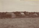
| Date: | 1915 |
|---|---|
| Description: | The Old Mission Inn by what is believed to be the first Protestant religious building in Wisconsin called Old Mission Congregational Church. |
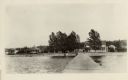
| Date: | 1934 |
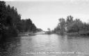
|---|---|
| Description: | View from water of footbridge crossing lagoon at Big Bay on Madeline Island. |

| Date: | 1845 |
|---|---|
| Description: | This map shows lakes, rivers, Chippewa land, the U.S. Mineral Land Agency, boundary between U.S. and Canada, Methodist and Catholic missions, and American ... |

| Date: | 1847 |
|---|---|
| Description: | This map identifies surveyed areas of the Upper Peninsula and shows lakes, rivers, and islands in portions of Wisconsin, Minnesota, Michigan, and upper Can... |
If you didn't find the material you searched for, our Library Reference Staff can help.
Call our reference desk at 608-264-6535 or email us at: