 Filter: Categories of Wisconsin Historical Images
Filter: Subject of Lakes
Filter: Subject of lumber trade
Filter: Categories of Wisconsin Historical Images
Filter: Subject of Lakes
Filter: Subject of lumber trade
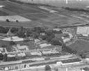
| Date: | 1958 |
|---|---|
| Description: | Aerial photograph showing the J.S. Timlin Lumber Company, 2702 University Avenue, as well as Doctors Park, the Veterans Hospital, and the First Unitarian S... |

| Date: | 1891 |
|---|---|
| Description: | Bird's-eye view of Eau Claire. |

| Date: | 08 20 1930 |
|---|---|
| Description: | Elevated view of the Madison skyline from the University of Wisconsin-Madison Field House, showing the Wisconsin State Capitol and Gateway Lumber Co., 1429... |

| Date: | 05 1959 |
|---|---|
| Description: | The foundation stones from the hardwood lumber mill constructed by F. Weyerhaeuser in 1885 on the north shore of Bowker Lake. |

| Date: | 05 1959 |
|---|---|
| Description: | The foundation stones from the hardwood lumber mill constructed by F. Weyerhaeuser in 1885 on the north shore of Bowker Lake. |

| Date: | 05 1959 |
|---|---|
| Description: | The foundation stones from the hardwood lumber mill constructed by F. Weyerhaeuser in 1885 on the north shore of Bowker Lake. |

| Date: | 05 1959 |
|---|---|
| Description: | The foundation stones from the hardwood lumber mill constructed by F. Weyerhaeuser in 1885 on the north shore of Bowker Lake. Hills are in the distance. |
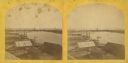
| Date: | 1870 |
|---|---|
| Description: | Stereograph of an elevated view of the lumbering industry on the Fox River. Lake Winnebago is in the background. |

| Date: | 1910 |
|---|---|
| Description: | Aerial view looking toward Lake Wingra. In the foreground is the Yawkey-Crowley Lumber Yard. The company built it's warehouse at 1542 Monroe Street between... |
| Date: | 1939 |
|---|---|
| Description: | A view from water of the Thunder Lake Lumber Co., one of the largest sawmills in Rhinelander. It was located on Lake Creek and operated until 1937. |
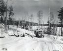
| Date: | 03 1941 |
|---|---|
| Description: | An International K-5 truck drives on a snow-covered hillside road in Eagle Lake, Ontario, Canada to deliver cut logs. |

| Date: | 1917 |
|---|---|
| Description: | This map, which highlights the land for sale by the Rust-Owen Lumber Company in the towns of Drummond, Cable and Grandview, Bayfield County, Wisconsin, sho... |

| Date: | 1925 |
|---|---|
| Description: | Shows buildings, piers, winter and summer levels, and resort lands. Depths shown by isolines. Relief shown by contours. From the E.P. Sherry papers relatin... |

| Date: | 1889 |
|---|---|
| Description: | Shows city limits, railroads, mills, schools, cemeteries, dams, parks, lumber yards, log canals, log reservoir, Chippewa River, Eau Claire River, and Half ... |

| Date: | 1908 |
|---|---|
| Description: | Title at top: "G.F. Sanborn Company Timber and Farming Lands." Map shows acreages, roads, railroads, and swamps in parts of Vilas and Oneida counties. |

| Date: | 1982 |
|---|---|
| Description: | This standard U.S.G.S. topographic map was annotated by civil engineer and railroad historian James P. Kaysen to show the location of existing and defunct ... |

| Date: | 1972 |
|---|---|
| Description: | A topographic map of the Blackwell quadrangle. |
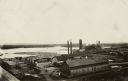
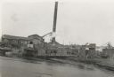
| Date: | 1900 |
|---|---|
| Description: | Elevated view of a lumber plant, with large stacks of lumber stacked around it. A lake is behind the plant. |
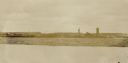
| Date: | |
|---|---|
| Description: | View across water towards logs floating along the lake. Several buildings, including a water tower and a silo, are on the opposite shoreline. |
If you didn't find the material you searched for, our Library Reference Staff can help.
Call our reference desk at 608-264-6535 or email us at:
