 Filter: Categories of Wisconsin Historical Images
Filter: Subject of Lakes
Filter: Subject of industries
Filter: Categories of Wisconsin Historical Images
Filter: Subject of Lakes
Filter: Subject of industries

| Date: | 1884 |
|---|---|
| Description: | A sign for Fauerbach's Brewery depicting a young woman and the brewery. |
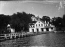
| Date: | 1915 |
|---|---|
| Description: | View from water of Bernard's Boat House on Lake Mendota, adjacent to the present James Madison Park. |
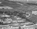
| Date: | 1958 |
|---|---|
| Description: | Aerial photograph showing the J.S. Timlin Lumber Company, 2702 University Avenue, as well as Doctors Park, the Veterans Hospital, and the First Unitarian S... |
| Date: | |
|---|---|
| Description: | View east of buildings and lake from the dome of the Exposition building. Lumber is stacked on the right. |

| Date: | |
|---|---|
| Description: | Upper Mississippi, view through trees down the old quarry road at Frontenac. Lake in background. |
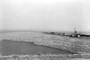
| Date: | 1936 |
|---|---|
| Description: | Elevated view of logs tugged across Lake Superior to the harbor at Ashland. |
| Date: | 1907 |
|---|---|
| Description: | A steam-powered dredge anchored in Monona Bay is filling in Brittingham Park. |

| Date: | 1867 |
|---|---|
| Description: | Birds-eye drawing of Beaver Dam, Dodge Co., depicting street names and street layout, houses, rivers, lakes, and trees. A reference key at the bottom of th... |

| Date: | 1867 |
|---|---|
| Description: | Birds eye drawing of Fond du Lac depicts street names and street layouts, houses, buildings, trees, and the Fond du Lac River. A reference key at the botto... |

| Date: | 1885 |
|---|---|
| Description: | Bird's-eye view of Sheboygan, with inset of J.J. Volrath Manufacturing Company. |

| Date: | 1913 |
|---|---|
| Description: | Bird's-eye map of Superior. "The New Steel Center." |

| Date: | 1891 |
|---|---|
| Description: | Bird's-eye view of Eau Claire. |
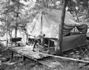
| Date: | 06 27 1931 |
|---|---|
| Description: | Man sawing wood in front of a tent in the woods at the University of Wisconsin Tent Colony. The tent is set up on a wood platform. Also known as Camp Galli... |

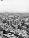
| Date: | 08 20 1930 |
|---|---|
| Description: | Elevated view of the Madison skyline from the University of Wisconsin-Madison Field House, showing the Wisconsin State Capitol and Gateway Lumber Co., 1429... |
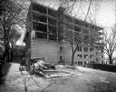
| Date: | 05 01 1931 |
|---|---|
| Description: | State Office Building, 1 W. Wilson Street, under construction. This is a side view, with two posters advertising: "10 Nights in a Barroom" at the Orpheum T... |
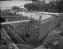
| Date: | 08 01 1930 |
|---|---|
| Description: | Basement and ground floor of State Office Building, 1 W. Wilson Street, under construction. View toward Lake Monona. |
| Date: | 03 28 1929 |
|---|---|
| Description: | Men working on the concrete forms for the roof of the addition to the University of Wisconsin hydraulics laboratory, 660 N. Park Street looking north over ... |

| Date: | 03 28 1929 |
|---|---|
| Description: | Elevated view from the south east of men constructing the concrete forms for the roof of the addition to the University of Wisconsin-Madison hydraulics lab... |

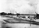
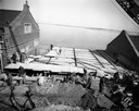
| Date: | 03 05 1929 |
|---|---|
| Description: | Tank moving up the ramp at Hydraulics Laboratory, 660 N. Park Street, at the University of Wisconsin-Madison. |
If you didn't find the material you searched for, our Library Reference Staff can help.
Call our reference desk at 608-264-6535 or email us at:
