 Filter: Categories of Wisconsin Historical Images
Filter: Subject of Lakes
Filter: Subject of human settlements
Filter: Categories of Wisconsin Historical Images
Filter: Subject of Lakes
Filter: Subject of human settlements
| Date: | 1885 |
|---|---|
| Description: | South Pinckney Street between East Washington Avenue (left) and King Street (right). On the right is the Marquette neighborhood. The large structure at the... |
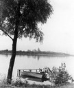
| Date: | 1945 |
|---|---|
| Description: | View of the Wisconsin State Capitol from across Lake Monona with a tree, pier and boat in the foreground. |
| Date: | 1948 |
|---|---|
| Description: | Wisconsin State Capitol from the south side of Monona Bay. |

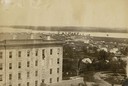
| Date: | 05 09 1908 |
|---|---|
| Description: | Kite aerial panoramic photograph of the central business district. In the distance is Lake Mendota. The fire damaged Wisconsin State Capitol is in the cent... |
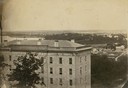
| Date: | 1861 |
|---|---|
| Description: | View of Madison from Main Hall, now Bascom Hall, on the University of Wisconsin-Madison campus. South Hall is in the foreground, with several residences an... |
| Date: | 1861 |
|---|---|
| Description: | View of Madison from Main Hall, now Bascom Hall, on the University of Wisconsin-Madison campus. South Hall is in the foreground with several residences an... |

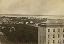
| Date: | 1861 |
|---|---|
| Description: | View of Madison from Main Hall, now Bascom Hall, on the University of Wisconsin-Madison campus looking up State Street toward the second Wisconsin State Ca... |
| Date: | 1861 |
|---|---|
| Description: | View of Madison from Main Hall, now Bascom Hall, on the University of Wisconsin-Madison campus. North Hall is in the foreground with several residences and... |
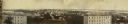
| Date: | 11 11 1861 |
|---|---|
| Description: | Panoramic view of Madison from Main Hall, now Bascom Hall, on the University of Wisconsin campus. North Hall and South Hall are in the foreground. Lake Men... |

| Date: | 1910 |
|---|---|
| Description: | Map of Dane County rural delivery in Madison and the town of Westport. |

| Date: | 1839 |
|---|---|
| Description: | This map shows the hydrology of Madison and its vicinity at the height of interest in a proposed Milwaukee and Rock River Canal. It was made by Thomas Jeff... |

| Date: | 1832 |
|---|---|
| Description: | Hand-drawn map in two parts of the route of Governor J.D. Doty. Probably made by Doty in 1832 as a result of his travels with Alexander J. Center. |

| Date: | 1910 |
|---|---|
| Description: | Map of the general plan of the district of the Four Lakes. |
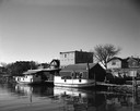
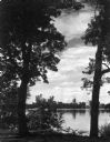
| Date: | 05 05 1963 |
|---|---|
| Description: | View across water towards two fishing boats moored at a dock. |
| Date: | 1899 |
|---|---|
| Description: | View along shoreline of University of Wisconsin-Madison buildings across Lake Mendota from Carroll Street. The Armory (Red Gym or Old Red), a boathouse, an... |

| Date: | 1950 |
|---|---|
| Description: | Aerial view of the Frank Lloyd-Wright-dsigned Unitarian Church under construction and the Veteran's Administration Hospital, also under construction, to th... |
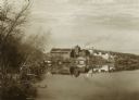
| Date: | 1906 |
|---|---|
| Description: | View of Madison from Lake Monona with the Wisconsin State Capitol building in the background. This view of Brittingham Park shows a part of the park shortl... |
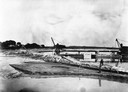
| Date: | 1907 |
|---|---|
| Description: | A steam-powered dredge anchored in Monona Bay is filling in Brittingham Park. |

| Date: | 1904 |
|---|---|
| Description: | Monona Bay from the railroad trestle looking southwest, close to where the railroad tracks cross North Shore Drive, (now Brittingham Park), with old houses... |

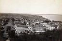
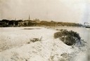
| Date: | 1885 |
|---|---|
| Description: | Mining and lumbering provided the impetus for the development of northern Wisconsin and Ashland was ideally situated to become a leading city of the "new W... |
If you didn't find the material you searched for, our Library Reference Staff can help.
Call our reference desk at 608-264-6535 or email us at: