 Filter: Categories of Wisconsin Historical Images
Filter: Subject of Lakes
Filter: Subject of human settlements
Filter: Categories of Wisconsin Historical Images
Filter: Subject of Lakes
Filter: Subject of human settlements

| Date: | 1848 |
|---|---|
| Description: | In 1849, northern Wisconsin was composed of huge sectional regions such as Chippewa, Portage, Brown and Crawford, whereas southern Wisconsin was constitute... |

| Date: | 1873 |
|---|---|
| Description: | Newspaper reproduction of an etching of the Milwaukee River. |
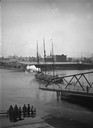
| Date: | |
|---|---|
| Description: | A view of the D.G. & M. Depot from the East Water Street Bridge. |
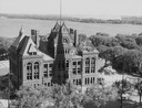
| Date: | 1958 |
|---|---|
| Description: | Elevated view of the Dane County Courthouse as it is being razed. Much of it is still intact in this image. Lake Monona and Monona Bay are in the distance. |

| Date: | 1856 |
|---|---|
| Description: | View looking west from Lake Michigan with several steam ships and sailing vessels in harbor. There is a lighthouse to left of center, along shoreline. |
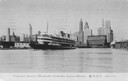
| Date: | |
|---|---|
| Description: | The screw passenger excursion vessel, "Christopher Columbus," leaving Chicago. Skyline of Chicago is in background with one building with sign reading Armo... |
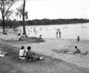
| Date: | 08 30 1953 |
|---|---|
| Description: | View from the beach of people swimming, playing in the sand, and sunbathing. |

| Date: | 1861 |
|---|---|
| Description: | Drawn the first year of the Civil War, this colored 1861 map of Dane County shows its towns, cities and lakes. It includes insets of the wards of Madison a... |
| Date: | 08 24 1945 |
|---|---|
| Description: | Elevated view of the Wisconsin State Capitol from the roof of the Loraine Hotel. |
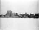
| Date: | 12 18 1955 |
|---|---|
| Description: | Downtown Madison lakeshore taken from Lake Monona in line with South Pinckney Street. Includes St. Raphael's steeple, 1 West Wilson Street state office bui... |

| Date: | 03 03 1957 |
|---|---|
| Description: | A view of Olin Terrace. The terrace and fountain were built in 1934 by CWA and FERA workers. It was designed by Frank Riley, Madison architect, in the Ital... |
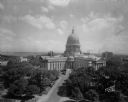
| Date: | 06 16 1928 |
|---|---|
| Description: | Elevated view of the Wisconsin State Capitol from the roof of the Loraine Hotel. In the background is Lake Mendota on the left, and on the right is Lake Mo... |
| Date: | 10 07 1930 |
|---|---|
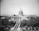
| Description: | View of the Wisconsin State Capitol across Lake Monona from Olin Park. |

| Date: | 07 10 1949 |
|---|---|
| Description: | Aerial view of Minocqua showing the surrounding lakes. |
| Date: | 1925 |
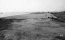
|---|---|
| Description: | Bare expanse of land with the Milwaukee lakeshore and the city in the distance. |

| Date: | |
|---|---|
| Description: | View from shoreline of the photographer, Carl A. Peterson, taking a moment to light his pipe while fishing from a boat near the family home. |
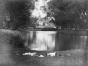
| Date: | |
|---|---|
| Description: | Two boys lying on the grass asleep in Tenney Park near the lagoon with a hat on the ground between them. The Sherman Avenue bridge and the Hausmann Brewery... |
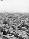
| Date: | |
|---|---|
| Description: | View east of buildings and lake from the dome of the Exposition building. Lumber is stacked on the right. |
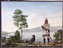
| Date: | |
|---|---|
| Description: | Watercolor of Canadian Prairie Indian at lake's shore with gun in hand and a recently hunted duck on the ground. A dog is at his feet. On the far shoreline... |

| Date: | 1876 |
|---|---|
| Description: | Bird's-eye view of Black Earth. |
If you didn't find the material you searched for, our Library Reference Staff can help.
Call our reference desk at 608-264-6535 or email us at: