 Filter: Categories of Wisconsin Historical Images
Filter: Subject of Lakes
Filter: Subject of human settlements
Filter: Reproduction Rights of Special Conditions
Filter: Categories of Wisconsin Historical Images
Filter: Subject of Lakes
Filter: Subject of human settlements
Filter: Reproduction Rights of Special Conditions

| Date: | 05 30 1973 |
|---|---|
| Description: | Memorial Union in the rain. Lake Mendota is visible on the left. In the foreground is the terrace area with trees and brightly colored chairs and tables. P... |

| Date: | 2013 |
|---|---|
| Description: | Map is the most extensive endeavor to date to accurately locate and document both prehistoric place names and natural features of the Menominee language wi... |

| Date: | 1941 |
|---|---|
| Description: | A detail of a Sanborn map showing areas at Langdon and Henry Streets, including Lake Lawn Place. |

| Date: | 1942 |
|---|---|
| Description: | Detail of a Madison Sanborn Map showing the Lake Mendota shoreline. The area shown is between the Blackhawk Country Club and Eagle Heights Woods. |

| Date: | 2010 |
|---|---|
| Description: | A man drives a tractor on John Nolen Drive along Lake Mendota with the Wisconsin State Capitol in the distance. He is on his was to a Red Power venue held ... |

| Date: | 01 1977 |
|---|---|
| Description: | A boy is blowing warm air on his little brother's hands to warm them up. They are standing on ice at James Madison Park. In the background are boats pulled... |
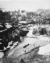
| Date: | 1977 |
|---|---|
| Description: | Elevated view across a granite quarry looking west, with Buffalo Lake in the background. Buildings of the town are between the quarry and the lake, and a p... |
If you didn't find the material you searched for, our Library Reference Staff can help.
Call our reference desk at 608-264-6535 or email us at: