 Filter: Categories of Wisconsin Historical Images
Filter: Subject of Lakes
Filter: Subject of human settlements
Filter: Community of Fond du Lac
Filter: Categories of Wisconsin Historical Images
Filter: Subject of Lakes
Filter: Subject of human settlements
Filter: Community of Fond du Lac

| Date: | 1867 |
|---|---|
| Description: | Birds eye drawing of Fond du Lac depicts street names and street layouts, houses, buildings, trees, and the Fond du Lac River. A reference key at the botto... |
| Date: | 1920 |
|---|---|
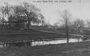
| Description: | View across pond looking towards the Buena Vista house on Lake de Neveu. Caption reads: "The House Buena Vista The de Neveu Farm". |

| Date: | 1920 |
|---|---|
| Description: | View looking down hill towards the Buena Vista house on Lake de Neveu. Caption reads: "The House Buena Vista The de Neveu Farm". |
| Date: | |
|---|---|
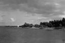
| Description: | View across water towards the shoreline on the right, with a lighthouse in the distance. |

| Date: | 1857 |
|---|---|
| Description: | Quarter section of a map of the city of Fond du Lac featuring an illustration of the Lewis House. |

| Date: | 1840 |
|---|---|
| Description: | Shows plat of town, local streets, Fond du Lac River, and part of Lake Winnebago. |

| Date: | 1874 |
|---|---|
| Description: | Includes index to key buildings. Shows local streets, railroads, fairgrounds, mills, schools, churches, and part of Lake Winnebago. Streets running west to... |

| Date: | 1916 |
|---|---|
| Description: | Includes index to businesses, churches, and schools. Shows local streets, buildings, railroads, ward divisions, Fond du Lac River, and part of Lake Winneba... |

| Date: | 1956 |
|---|---|
| Description: | Includes street index. Shows local streets, parks, highways, railroads, Fond du Lac River, and part of lake Winnebago. Also includes text on points of inte... |

| Date: | 1956 |
|---|---|
| Description: | Includes street index and index to points of interest. Shows land ownership by name, plat of town, local streets, schools, parks, highways, railroads, ward... |

| Date: | 1800 |
|---|---|
| Description: | Shows plat of town, land ownership by name, local streets, courthouses, churches, hotels, mills, railroads, railroad stations, lakes, and rivers. Includes ... |

| Date: | 1800 |
|---|---|
| Description: | Ink and watercolor on tracing paper. Shows plat of town, local streets, Fond du Lac River, and part of Lake Winnebago. |

| Date: | 1836 |
|---|---|
| Description: | This map shows land parcels, streets, the Fond du Lac River, Lake Winnebaygo (Winnebago), and blocks. Certification is on the left hand corner. The back of... |

| Date: | 1904 |
|---|---|
| Description: | Map showing lots, additions, and wards within the city limits, as well as some landownership. The streets are labeled, as is Lake Winnebago, rivers, railro... |

| Date: | 1906 |
|---|---|
| Description: | Elevated view of central Fond Du Lac. Lake Winnebago is in the distance. Churches and other buildings are in the foreground. Caption reads: "Fond du Lac, W... |
| Date: | 1910 |
|---|---|
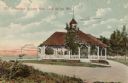
| Description: | Hand-colored view of the Lake Park Pavillion at Lake Winnebago. Caption reads: "Pavillion[sic] in Lake Park, Fond du Lac, Wis." |
If you didn't find the material you searched for, our Library Reference Staff can help.
Call our reference desk at 608-264-6535 or email us at: