 Filter: Categories of Wisconsin Historical Images
Filter: Subject of Lakes
Filter: Subject of historic sites
Filter: Categories of Wisconsin Historical Images
Filter: Subject of Lakes
Filter: Subject of historic sites

| Date: | 1835 |
|---|---|
| Description: | Little Lake Butte Des Morts just north of Lake Winnebago where Governor Lewis Cass of Michigan, and Thomas McKenney, head of the Bureau of Indian Affairs (... |
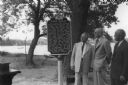
| Date: | 06 26 1955 |
|---|---|
| Description: | Arthur Melster, President of Cambridge Foundation; K.K. Amundson. M.D. of Cambridge; and W.T. Webb of Evinrude Motors, look at the Lake Ripley Ole Evinrude... |
| Date: | 1905 |
|---|---|
| Description: | View across water towards Old Mission, as seen from the pier with Old Mission Congregational Church behind it. This Mission was established in 1830 by Fred... |

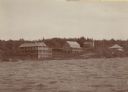
| Date: | 1960 |
|---|---|
| Description: | View of Ennis Lake, also known as Fountain Lake, located in the John Muir Memorial Park near Montello. As a boy, John Muir lived with his family on the sho... |

| Date: | 1960 |
|---|---|
| Description: | View of Ennis Lake, also known as Fountain Lake, located in the John Muir Memorial Park near Montello. As a boy, John Muir lived with his family on the sho... |

| Date: | 1939 |
|---|---|
| Description: | A color, pictorial map. Scale: 10 miles to the inch. Shows state parks and forests, proposed state parkways, proposed state monuments and memorials, nation... |
| Date: | 1931 |
|---|---|
| Description: | This map "sets out the more important points of historic interest designated by the National Society of Colonial Dames in Wisconsin" and includes illustrat... |

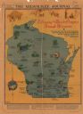
| Date: | 1941 |
|---|---|
| Description: | This pictorial map of Wisconsin with historical text highlights the history of the state and identifies places of interest, Indian villages, missions, trad... |

| Date: | 1961 |
|---|---|
| Description: | This 1961 map of Ozaukee County, Wisconsin, identifies historic sites and landmarks in the county. Cities and villages, roads, and lakes and streams are al... |
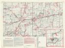
| Date: | |
|---|---|
| Description: | This map shows the locations of historic sites and points of interest in Rusk County, Wisconsin. A location key, descriptions of the historical importance ... |

| Date: | 1960 |
|---|---|
| Description: | This mid-20th century tourist brochure for Bayfield County, Wisconsin, includes a map of the county showing towns, cities and villages, highways and roads,... |
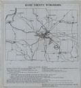
| Date: | 1930 |
|---|---|
| Description: | Shows points of historic interest in Dane County; includes explanation of historical points of interest and corresponding symbols. "Map of historic sites i... |

| Date: | 1950 |
|---|---|
| Description: | Wisconsin Historical Marker near Trout Lake. The marker recognizes the first ever forest patrol flight. The marker text reads: "FIRST FOREST PATROL FLI... |
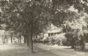
| Date: | 1940 |
|---|---|
| Description: | A row of maple trees lines the brick walkway along the main house at Black Point. There are benches on the lawn; Geneva Lake is in the background. A gable ... |

| Date: | 1996 |
|---|---|
| Description: | This map shows roads, lakes, points of interest including colleges, trails, historic communities and sites, museums, and parks. Also included are descripti... |

| Date: | 1970 |
|---|---|
| Description: | This photocopy map shows the locations of historic buildings, as well as all other buildings in the isthmus. The map also includes photographs of selected ... |

| Date: | 10 15 1955 |
|---|---|
| Description: | Neil LeMany, Chief Forest Ranger at the Forest Protection Headquarters in Tomahawk, C.L. Harrington, superintendent of the Forest and Parks Division of the... |
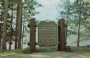
| Date: | 1969 |
|---|---|
| Description: | Historical marker on the shore of Flambeau Lake. Erected 1937. |
If you didn't find the material you searched for, our Library Reference Staff can help.
Call our reference desk at 608-264-6535 or email us at:
