 Filter: Categories of Wisconsin Historical Images
Filter: Subject of Lakes
Filter: Subject of fraternal organizations
Filter: Categories of Wisconsin Historical Images
Filter: Subject of Lakes
Filter: Subject of fraternal organizations
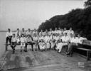
| Date: | 08 05 1931 |
|---|---|
| Description: | Acacia Fraternity group portrait, in street clothes, on the pier behind the fraternity house at 108 Langdon Street. |

| Date: | 10 09 1928 |
|---|---|
| Description: | Front view from walk of the Phi Gamma Delta fraternity house, looking north, at 16 Langdon Street. |

| Date: | 1949 |
|---|---|
| Description: | Color bird's-eye map of the University of Wisconsin-Madison as it was midcentury, with two co-eds, several photographs of campus landmarks around edges, an... |

| Date: | 1917 |
|---|---|
| Description: | Brick house at 640 North Frances Street, erected in 1906 for the Delta Upsilon Fraternity. |

| Date: | 1917 |
|---|---|
| Description: | A view of the shore, looking southeast from Lake Mendota. At left is the Thomas E. Brittingham residence and boathouse, 640 North Henry Street; center is ... |
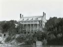
| Date: | 1924 |
|---|---|
| Description: | 124 Langdon Street, viewed from Lake Mendota. The house was designed by Madison architect Frank Riley and built in 1924 for the Kappa Sigma fraternity. T... |

| Date: | 1928 |
|---|---|
| Description: | Illustrated map of points of interest, including University buildings, parks, athletic venues, fraternity and sorority houses, and state buildings. |

| Date: | 1929 |
|---|---|
| Description: | Shows fraternities, sororities, major rooming houses, private and university buildings, and university property. Oriented with north slightly to the right. |

| Date: | 1956 |
|---|---|
| Description: | Map reads: "TAX EXEMPT LAND in the CITY OF MADISON". There is a legend of "Government Land" represented in stripes, "Religious and Fraternal Organization" ... |

| Date: | 1907 |
|---|---|
| Description: | Shows public buildings, hotels, fraternity houses, and private houses. Index of fraternities and sororities, residences, public buildings, hotels, places o... |

| Date: | 08 1902 |
|---|---|
| Description: | A detail of a Madison Sanborn map showing Mendota Court. |

| Date: | 1941 |
|---|---|
| Description: | A detail of a Sanborn map showing areas at Langdon and Henry Streets, including Lake Lawn Place. |

| Date: | 1908 |
|---|---|
| Description: | A detail of a Madison Sanborn map that includes the University of Wisconsin Boat House, UW Gymnasium & Armory (The Red Gym), fraternity houses, and the YMC... |

| Date: | |
|---|---|
| Description: | Exterior northeast view from street towards the house at 627 North Lake Street, at the intersection of Lake Street and Mendota Court. Lake Mendota is in th... |

| Date: | 07 1954 |
|---|---|
| Description: | Group portrait of clowns standing beside and on a car decorated with the Zor Shriners logo. On the front of the car a large horn labeled "Zor Shrine" is mo... |

| Date: | |
|---|---|
| Description: | View across water towards the shoreline of the eastern isthmus of Madison, including the MG&E power plant smokestacks. A group of people appear to be fishi... |
If you didn't find the material you searched for, our Library Reference Staff can help.
Call our reference desk at 608-264-6535 or email us at: