 Filter: Categories of Wisconsin Historical Images
Filter: Subject of Lakes
Filter: Subject of commercial strips
Filter: Categories of Wisconsin Historical Images
Filter: Subject of Lakes
Filter: Subject of commercial strips

| Date: | 12 07 1952 |
|---|---|
| Description: | Fauerbach Brewery, 651-653 Williamson Street, at the corner of South Blount Street and Williamson Street. The view includes R.J. Olson Glass Co., 625 Willi... |
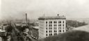
| Date: | 1927 |
|---|---|
| Description: | Elevated view looking east from the Wisconsin State Capitol down East Washington Avenue. |

| Date: | |
|---|---|
| Description: | Aerial view of a developed strip of land on Barnegat Bay showing the Atlantic ocean, houses, lakes, railroad tracks, a marina and a jetty in the distance. |

| Date: | 1954 |
|---|---|
| Description: | Elevated view from the Wisconsin State Capitol looking west up State Street toward the University of Wisconsin. Frozen Lake Monona is on the right. |
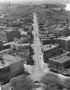
| Date: | 1959 |
|---|---|
| Description: | Elevated view of State Street from the Wisconsin State Capitol building. Lake Mendota is on the far right. |

| Date: | 1989 |
|---|---|
| Description: | This color coded map shows the various rivers, lakes, bays, and islands that make up the harbor. It includes an index of industries (maritime and non-marit... |
If you didn't find the material you searched for, our Library Reference Staff can help.
Call our reference desk at 608-264-6535 or email us at: