 Filter: Categories of Wisconsin Historical Images
Filter: Subject of Lakes
Filter: Subject of bridges
Filter: Categories of Wisconsin Historical Images
Filter: Subject of Lakes
Filter: Subject of bridges
| Date: | |
|---|---|
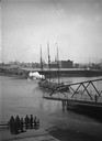
| Description: | A view of the D.G. & M. Depot from the East Water Street Bridge. |

| Date: | 1856 |
|---|---|
| Description: | View looking west from Lake Michigan with several steam ships and sailing vessels in harbor. There is a lighthouse to left of center, along shoreline. |
| Date: | |
|---|---|
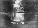
| Description: | Two boys lying on the grass asleep in Tenney Park near the lagoon with a hat on the ground between them. The Sherman Avenue bridge and the Hausmann Brewery... |
| Date: | |
|---|---|
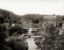
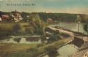
| Description: | Elevated view of Mirror Lake Mill with bridge in foreground. Two women are standing on the bridge looking down at the river. |

| Date: | |
|---|---|
| Description: | View from a stone bridge towards Vilas Park, with children riding the carousel (merry-go-round) and a kiddie train adjacent to the lagoon. |

| Date: | 1884 |
|---|---|
| Description: | Bird's-eye map of Delavan with inset of the State Institute for Deaf and Dumb. |

| Date: | 1885 |
|---|---|
| Description: | Bird's-eye map of Oconomowoc. |

| Date: | 1868 |
|---|---|
| Description: | Bird's-eye map of Portage, with insets of the Court House and the Public School. |

| Date: | 1885 |
|---|---|
| Description: | Bird's-eye view of Sheboygan, with inset of J.J. Volrath Manufacturing Company. |

| Date: | 1891 |
|---|---|
| Description: | Bird's-eye view of Eau Claire. |

| Date: | 1870 |
|---|---|
| Description: | Bird's-eye view of Whitewater, with insets. |

| Date: | 1874 |
|---|---|
| Description: | Elevated view from hill of Clinton, now Rockdale. Three men are in the middle distance, looking east across Koshonong Creek towards a mill dam, bridge and ... |
| Date: | 1910 |
|---|---|
| Description: | View across water towards the Inlet Bridge on Delavan Lake. Caption reads: "Inlet Bridge, Delavan Lake". |
| Date: | 1905 |
|---|---|
| Description: | Elevated view of a pond, a stream, and a lake, with a road dividing the pond and stream from the lake. Industrial buildings and a smokestack are in the bac... |
| Date: | 1910 |
|---|---|
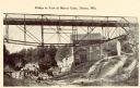
| Description: | Photographic postcard of the bridge near a mill. Caption reads: "Bridge at Foot of Mirror Lake, Delton, Wis." |
| Date: | |
|---|---|
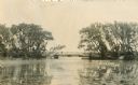
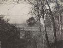
| Description: | Elevated view of a bridge. Trees are in the foreground, with Lake Mendota and the far shoreline in the distance. Original caption reads: "Rustic Bridge on ... |
If you didn't find the material you searched for, our Library Reference Staff can help.
Call our reference desk at 608-264-6535 or email us at:


