 Filter: Categories of Wisconsin Historical Images
Filter: Subject of Lakes
Filter: Subject of arboretums
Filter: Categories of Wisconsin Historical Images
Filter: Subject of Lakes
Filter: Subject of arboretums

| Date: | 1930 |
|---|---|
| Description: | Aerial view of the University of Wisconsin-Madison Arboretum including a portion of Lake Wingra and surrounding residential neighborhoods. |

| Date: | 1961 |
|---|---|
| Description: | View over beltline of University of Wisconsin-Madison Arboretum along Lake Wingra. Lake Mendota is on upper left, and Lake Monona is on the right, with the... |
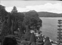
| Date: | |
|---|---|
| Description: | Elevated view of Hunnewell arboretum featuring a a hill with rows of topiary, Lake Wauban and surrounding woods. |

| Date: | 1948 |
|---|---|
| Description: | This 1948 map shows contour and spot depths in Lake Wingra in Madison, Wisconsin. The shore outline is based on a 1940 aerial photograph. |
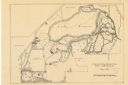
| Date: | 05 1938 |
|---|---|
| Description: | Map of the University of Wisconsin-Madison arboretum and wild life refuge. Roads are labelled, left to right: "Nakoma Road," "Monroe St.," "Manitou Way," "... |

| Date: | 1970 |
|---|---|
| Description: | Map features a legend of roads, trails, points of interest, buildings, and types of vegetation. To the right are "ARBORETUM REGULATIONS" regarding hours, p... |
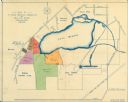
| Date: | 1920 |
|---|---|
| Description: | This map shows an arboretum and wildlife refuge in Madison, Wisconsin. There are color coded parcels "F" through "K" with acreages, as well as area around ... |

| Date: | 1932 |
|---|---|
| Description: | This map shows local streets, section lines, Nakoma Country Club, part of Lake Forest, and part of Lake Wingra. The map includes a legend showing areas of ... |

| Date: | 1924 |
|---|---|
| Description: | This pictorial map focuses on the Madison Isthmus, Lake Mendota, Lake Monona, Lake Wingra, and shows points of historical interest, buildings, parks, and I... |

| Date: | 1933 |
|---|---|
| Description: | Blue print and blue line print maps that show local streets, Nakoma Country Club, part of Lake Forest, and part of Lake Wingra. A legend is included that s... |

| Date: | 10 10 2014 |
|---|---|
| Description: | View from shoreline, with cattails and tall grasses growing in the foreground, on the shore of Lake Wingra. Geese are swimming and diving on the lake, and ... |

| Date: | 10 16 2014 |
|---|---|
| Description: | Trees, shrubs, and tall grasses frame the view of Lake Wingra. Lily pads are growing on the lake surface. Trees from the UW Arboretum, just starting to tur... |
If you didn't find the material you searched for, our Library Reference Staff can help.
Call our reference desk at 608-264-6535 or email us at: