Filter: Categories of Wisconsin Historical Images
Filter: Subject of Lakes
Filter: County of Waukesha
Filter: Categories of Wisconsin Historical Images
Filter: Subject of Lakes
Filter: County of Waukesha

| Date: | 1935 |
|---|---|
| Description: | Lake Okauchee lighthouse. Buildings are in the background along a tree-covered shoreline. |
| Date: | 09 04 1906 |
|---|---|
| Description: | Three boys on the shore of Pewaukee Lake. One boy is fishing, while the other two observe. A boat dock and boathouse are in the background. |
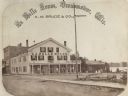
| Date: | 1867 |
|---|---|
| Description: | A summer resort, situated on the banks of Fowler and La Belle Lakes, in the village of Oconomowoc, thirty miles from Milwaukee on the St. Paul R.R. Men sta... |

| Date: | 1870 |
|---|---|
| Description: | View from shore of sailboat anchored on the lake. There appears to be an island in the upper left. |
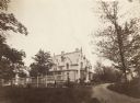
| Date: | 1870 |
|---|---|
| Description: | A large, white brick building is in the middle center, surrounded by trees. A smaller white building is in the right background. In front of the building... |

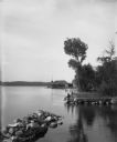
| Date: | |
|---|---|
| Description: | View across water towards the Mayor's summer home as seen from across Pine Lake. Children and adults are standing in front of the two-story dwelling. To th... |

| Date: | 1860 |
|---|---|
| Description: | Stereograph of the Townsend House boathouse across a lake. |
| Date: | 1953 |
|---|---|
| Description: | Interior perspective drawing of the living room of the Fred Graber house designed and drawn by architect John Randal McDonald. |

| Date: | 1924 |
|---|---|
| Description: | Label submitted to the state of Wisconsin for trademark registration. "Blatz Waukesha Water, Bottled at the Springs, Waukesha WI, A natural spring water, s... |
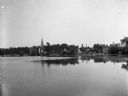
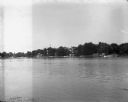
| Date: | 06 1900 |
|---|---|
| Description: | View across Lake La Belle toward lakeside factories, residences, and churches. |

| Date: | 11 14 1942 |
|---|---|
| Description: | This pictorial map illustrates Potawatomi Indian legends from the region of Lower Phantom Lake, labeled Howitt Lake on the map, Phantom Lake, and Mukwonag... |

| Date: | |
|---|---|
| Description: | This 19th century manuscript map of the Town of Oconomoc, Waukesha County, Wisconsin, is drawn on a printed township grid. It shows landownership and lakes... |

| Date: | 1873 |
|---|---|
| Description: | This late 19th century map shows the lake region around Oconomowoc in Waukesha County and eastern Jefferson County, Wisconsin. The township and range grid,... |

| Date: | 1934 |
|---|---|
| Description: | This map of Waukesha County, Wisconsin, from the Wisconsin Land Inventory shows the township and range grid, sections, cities and villages, vegetation type... |

| Date: | 1891 |
|---|---|
| Description: | This late 19th century map shows the lake region around Oconomowoc in Waukesha County and eastern Jefferson County, Wisconsin. The township and range grid,... |

| Date: | 1876 |
|---|---|
| Description: | This late 19th century map by Increase Lapham shows the lake region around Oconomowoc in Waukesha County and eastern Jefferson County, Wisconsin. Cities an... |

| Date: | 1887 |
|---|---|
| Description: | This late 19th century map shows the lake region around Oconomowoc in Waukesha County and eastern Jefferson County, Wisconsin. Cities and villages, roads, ... |

| Date: | 1930 |
|---|---|
| Description: | This map of Waukesha County, Wisconsin, from the 1930s shows the township and range grid, towns, sections, cities and villages, highways and roads, railroa... |
If you didn't find the material you searched for, our Library Reference Staff can help.
Call our reference desk at 608-264-6535 or email us at: