 Filter: Categories of Wisconsin Historical Images
Filter: Subject of Lakes
Filter: County of Vilas
Filter: Categories of Wisconsin Historical Images
Filter: Subject of Lakes
Filter: County of Vilas

| Date: | |
|---|---|
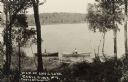
| Description: | Photographic postcard view of Boulder Lake surrounded by trees. Caption reads: "Boulder Junction, Wisconsin." |
| Date: | 1912 |
|---|---|
| Description: | Picnic party on the rocks along the shore, among the Apostle Islands in Lake Superior. |
| Date: | 1915 |
|---|---|
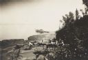
| Description: | View from shoreline of Trout Lake of a group of six men posed with the pilot, possibly Jack Vilas, on an early seaplane or flying boat floating in the wate... |
| Date: | 1912 |
|---|---|
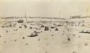
| Description: | This view is looking northeast from the site of Norway Springs at the north end of Trout Lake in the spring. In the foreground are tree stumps; in the back... |

| Date: | 1911 |
|---|---|
| Description: | View along shoreline towards the new boat house constructed of Norway pine logs at Trout Lake. It is part of the forest ranger complex. Caption reads: "Boa... |

| Date: | 1912 |
|---|---|
| Description: | View across water of the east shore of Trout Lake. Caption reads: "East Shore. Trout Lake, Vilas Co. Wis." |

| Date: | 1950 |
|---|---|
| Description: | Wisconsin Historical Marker near Trout Lake. The marker recognizes the first ever forest patrol flight. The marker text reads: "FIRST FOREST PATROL FLI... |
| Date: | 1954 |
|---|---|
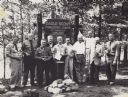
| Description: | Ten men are standing in a row in front of a sign marking the 25th anniversary of the Eagle Scout Forestry Camp. They are each holding an Eagle Scout trophy... |

| Date: | 11 16 1949 |
|---|---|
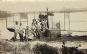
| Description: | Three men, Mackie, Breuer, and Harrington, are standing in front of Laura Lake. The far shoreline is in the far background. Laura Lake was surveyed by the ... |

| Date: | 1950 |
|---|---|
| Description: | Elevated view of fall color on Yellow Birch Lake on the Eagle Chain of Lakes. There is a boathouse on shoreline at the right obscured by trees. |
| Date: | 1905 |
|---|---|
| Description: | View looking down hill towards two people in rowboats near the shoreline on Anvil Lake, east of Eagle River, on STH 70. Caption reads: "Anvil Lake, Eagle R... |
| Date: | 1905 |
|---|---|
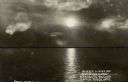
| Description: | Moonlight over Everett's Resort on Catfish Lake, east of Eagle River off of STH 70. Caption reads: "Moonlight Over Everett's Resort on Catfish Lake, Eagle ... |
| Date: | 1910 |
|---|---|
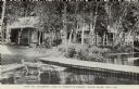
| Description: | View across water towards lakeside cabins among birch trees at the resort on Catfish Lake, east of Eagle River off of STH 70. There is a pier in the foregr... |

| Date: | 1930 |
|---|---|
| Description: | View across water towards Jack O'Lantern Lodge located on Taylor Lake, east of Eagle Lake on STH 70. Caption reads: "Jack O'Lantern Lodge, Eagle River, Wis... |
| Date: | 1930 |
|---|---|
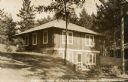
| Description: | View of cottage built into a hill on Taylor Lake east of Eagle River on STH 70. Caption reads: "Guest Cottage at Jack O'Lantern Lodge — Eagle River, Wis." |

| Date: | 1930 |
|---|---|
| Description: | Aerial photographic postcard of Jack O'Lantern Lodge on Taylor Lake east of Eagle River on STH70, including the forest area surrounding the shoreline. Capt... |

| Date: | 1920 |
|---|---|
| Description: | View toward a cabin among birch trees at the resort adjacent to the lake, on STH 17 south of Eagle River. Caption reads: "Indian Lake Resort, Eagle River, ... |
| Date: | 1905 |
|---|---|
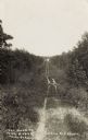
| Description: | The two-track unpaved road to "The Morey" northeast of Eagle River, on the east side of Otter Lake. Caption reads: "The Road to 'The Morey.'" |

| Date: | 02 1937 |
|---|---|
| Description: | This topographical map of the forest preserve shows highways, roads, trails, telephone lines, Native American reservations, Ranger sub-stations, state nurs... |

| Date: | 1853 |
|---|---|
| Description: | This map shows camps, forts, logging camps, lakes, roads, railroads, the Wisconsin River, and Lac Du Flambeau Indian Reservation. Some points of interest a... |
If you didn't find the material you searched for, our Library Reference Staff can help.
Call our reference desk at 608-264-6535 or email us at: