 Filter: Categories of Wisconsin Historical Images
Filter: Subject of Lakes
Filter: County of Milwaukee
Filter: Categories of Wisconsin Historical Images
Filter: Subject of Lakes
Filter: County of Milwaukee

| Date: | 1938 |
|---|---|
| Description: | Interior view of a fishing boat powered by an International PD-40 power unit and owned by Julius Dettloff. A man stands at the boat's wheel. |

| Date: | |
|---|---|
| Description: | View from shoreline of a group of people standing on a pier. Three people are in a boat along the side of the pier, and another boat with a roof is on the ... |

| Date: | 06 09 1901 |
|---|---|
| Description: | View across water of rowboats and canoes on small lake, perhaps Lake Park. On the far shoreline a large crowd is gathered, and on a hill behind them a buil... |

| Date: | 10 1900 |
|---|---|
| Description: | Aunt Helen and Will shaking hands in a clearing near the edge of a small lake at the Garden Place. |
| Date: | |
|---|---|
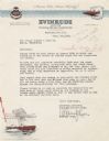
| Description: | Letterhead of the Evinrude Division of Outboard Motors Corporation of Milwaukee, Wisconsin, with the corporation logo and a man racing along in a boat with... |

| Date: | 1836 |
|---|---|
| Description: | This hand-colored manuscript map shows the township and section grid in southeastern Wisconsin, covering the area west to Sugar River and Four Lakes region... |

| Date: | 05 1846 |
|---|---|
| Description: | Hand-colored map of southeastern Wisconsin showing the counties of Dodge, Jefferson, Rock, Walworth, Racine (including modern-day Kenosha County), Waukesha... |
| Date: | 09 1900 |
|---|---|
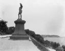
| Description: | View of a statue in Juneau Park, created by American sculptor Anne Whitney in 1887. The statue is a replica of the original which resides in Boston, Massac... |

| Date: | 1830 |
|---|---|
| Description: | A hand-drawn map of the township sectioning of Milwaukee, eastern Waukesha, northern Walworth, and Racine Counties. Other items shown in the map are the la... |

| Date: | 1844 |
|---|---|
| Description: | An ink on paper, hand-drawn map of Milwaukee County that shows the sectioning of townships, the boundary of the canal grant, roads, streams, lakes, includi... |

| Date: | 1858 |
|---|---|
| Description: | An ink on paper map of Milwaukee County and the eastern portion of Waukesha County that shows the townships of Oak Creek, Franklin, Greenfield, Wauwatosa, ... |

| Date: | 1976 |
|---|---|
| Description: | An 1876 reprinted map of the Township of Franklin, Milwaukee County, Wisconsin, that shows the land ownership and sectioning of the town, as well as the ro... |

| Date: | 1886 |
|---|---|
| Description: | A hand-colored map of Milwaukee County, Wisconsin that shows the township and range system, sections, towns, roads, railroads and rail stations, cities and... |

| Date: | 1891 |
|---|---|
| Description: | A hand-colored map of Milwaukee County, Wisconsin that shows the township and range system, sections, towns, roads, railroads and rail stations, cities and... |

| Date: | 1837 |
|---|---|
| Description: | A pen and ink on tracing paper, hand-drawn and colored map the proposed route of the Milwaukee and Rock River Canal, ranging from the Rock River in the wes... |

| Date: | 1838 |
|---|---|
| Description: | A map of the proposed route of the Milwaukee and Rock River Canal from Fort Atkinson on the Rock River in the west to the city of Milwaukee and Lake Michig... |

| Date: | 1830 |
|---|---|
| Description: | An ink on paper, hand-drawn map of the town of Milwaukee, showing the divisions and landownership within the town by private individuals as well as those l... |

| Date: | 1863 |
|---|---|
| Description: | Includes index to public buildings, churches, schools. Inset: Glidden & Lockwood’s addition. Gives names of some property owners. |

| Date: | 1877 |
|---|---|
| Description: | Two maps on one page, removed from an atlas. The first map shows Wisconsin and the upper peninsula of Michigan counties and townships while the second map ... |

| Date: | 1880 |
|---|---|
| Description: | Map created from original drawing and surveys taken by Silas Chapman. Bottom right corner features a reference key. There is a street guide on the left sid... |
If you didn't find the material you searched for, our Library Reference Staff can help.
Call our reference desk at 608-264-6535 or email us at: