Filter: Categories of Wisconsin Historical Images
Filter: Subject of Lakes
Filter: Community of Waupaca
Filter: Categories of Wisconsin Historical Images
Filter: Subject of Lakes
Filter: Community of Waupaca
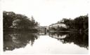
| Date: | 1940 |
|---|---|
| Description: | View of Taylor Lake and the entrance to Chain O' Lakes. |

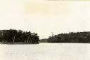
| Date: | 1910 |
|---|---|
| Description: | Aerial view of some of the 26 lakes known collectively as the Chain O' Lakes. Caption reads: "Aeroplane View of Chain O'Lakes, Waupaca, Wis." |

| Date: | 1896 |
|---|---|
| Description: | A map of the Chain-O-Lakes in Waupaca, including Indian trails. The path of the Waupaca Electric Railway from the Grand View Hotel to the Wisconsin Central... |

| Date: | 1941 |
|---|---|
| Description: | This pictorial map shows sites related to Indian legends, mounds, and trails in the Chain O' Lakes region in southwestern Waupaca County, Wisconsin. |

| Date: | 1898 |
|---|---|
| Description: | This 1896 map of the Chain-O-Lakes region of Waupaca County, Wisconsin, shows the lakes and streams, some topography, archaeological sites, roads, railroad... |

| Date: | 1898 |
|---|---|
| Description: | This 1898 map shows the contour depths of the Chain O' Lakes in Waupaca County, Wisconsin, and includes 15 cross sections of the lakes. Roads, parks, the W... |

| Date: | 1940 |
|---|---|
| Description: | Text on front reads: "View at Whispering Pines on Marl Lake, Chain O' Lakes, Waupaca, Wisconsin." Outdoor seating with canopies and a birdhouse on the shor... |
If you didn't find the material you searched for, our Library Reference Staff can help.
Call our reference desk at 608-264-6535 or email us at: