 Filter: Categories of Wisconsin Historical Images
Filter: Subject of Lakes
Filter: Community of Madison
Filter: Categories of Wisconsin Historical Images
Filter: Subject of Lakes
Filter: Community of Madison
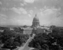
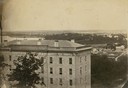
| Date: | 08 24 1945 |
|---|---|
| Description: | Elevated view of the Wisconsin State Capitol from the roof of the Loraine Hotel. |
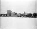
| Date: | 12 18 1955 |
|---|---|
| Description: | Downtown Madison lakeshore taken from Lake Monona in line with South Pinckney Street. Includes St. Raphael's steeple, 1 West Wilson Street state office bui... |

| Date: | 03 03 1957 |
|---|---|
| Description: | A view of Olin Terrace. The terrace and fountain were built in 1934 by CWA and FERA workers. It was designed by Frank Riley, Madison architect, in the Ital... |
| Date: | 06 16 1928 |
|---|---|
| Description: | Elevated view of the Wisconsin State Capitol from the roof of the Loraine Hotel. In the background is Lake Mendota on the left, and on the right is Lake Mo... |
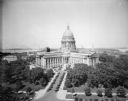
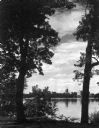
| Date: | 10 07 1930 |
|---|---|
| Description: | View of the Wisconsin State Capitol across Lake Monona from Olin Park. |
| Date: | |
|---|---|
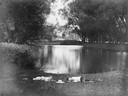
| Description: | Two boys lying on the grass asleep in Tenney Park near the lagoon with a hat on the ground between them. The Sherman Avenue bridge and the Hausmann Brewery... |
| Date: | 1885 |
|---|---|
| Description: | South Pinckney Street between East Washington Avenue (left) and King Street (right). On the right is the Marquette neighborhood. The large structure at the... |
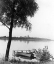
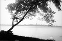
| Date: | 1945 |
|---|---|
| Description: | View of the Wisconsin State Capitol from across Lake Monona with a tree, pier and boat in the foreground. |
| Date: | 1948 |
|---|---|
| Description: | Wisconsin State Capitol from the south side of Monona Bay. |

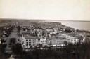
| Date: | 05 09 1908 |
|---|---|
| Description: | Kite aerial panoramic photograph of the central business district. In the distance is Lake Mendota. The fire damaged Wisconsin State Capitol is in the cent... |
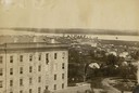
| Date: | 1861 |
|---|---|
| Description: | View of Madison from Main Hall, now Bascom Hall, on the University of Wisconsin-Madison campus. South Hall is in the foreground, with several residences an... |
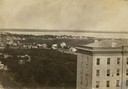
| Date: | 1861 |
|---|---|
| Description: | View of Madison from Main Hall, now Bascom Hall, on the University of Wisconsin-Madison campus. South Hall is in the foreground with several residences an... |

| Date: | 1861 |
|---|---|
| Description: | View of Madison from Main Hall, now Bascom Hall, on the University of Wisconsin-Madison campus looking up State Street toward the second Wisconsin State Ca... |
| Date: | 1861 |
|---|---|
| Description: | View of Madison from Main Hall, now Bascom Hall, on the University of Wisconsin-Madison campus. North Hall is in the foreground with several residences and... |
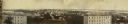
| Date: | 11 11 1861 |
|---|---|
| Description: | Panoramic view of Madison from Main Hall, now Bascom Hall, on the University of Wisconsin campus. North Hall and South Hall are in the foreground. Lake Men... |

| Date: | 1910 |
|---|---|
| Description: | Map of Dane County rural delivery in Madison and the town of Westport. |

| Date: | 1839 |
|---|---|
| Description: | This map shows the hydrology of Madison and its vicinity at the height of interest in a proposed Milwaukee and Rock River Canal. It was made by Thomas Jeff... |

| Date: | 1839 |
|---|---|
| Description: | A map of the Wiskonsin [sic] and Neenah or Fox Rivers. |

| Date: | 1832 |
|---|---|
| Description: | Hand-drawn map in two parts of the route of Governor J.D. Doty. Probably made by Doty in 1832 as a result of his travels with Alexander J. Center. |

| Date: | 1910 |
|---|---|
| Description: | Map of the general plan of the district of the Four Lakes. |
If you didn't find the material you searched for, our Library Reference Staff can help.
Call our reference desk at 608-264-6535 or email us at: