 Filter: Categories of Wisconsin Historical Images
Filter: Subject of Lakes
Filter: Creator Name of Greene, Howard
Filter: Categories of Wisconsin Historical Images
Filter: Subject of Lakes
Filter: Creator Name of Greene, Howard

| Date: | 1911 |
|---|---|
| Description: | A small island with tall trees in Kasakokwog Lake, which was called Anna Lake by the rangers. The far shoreline is in the background. |

| Date: | 1911 |
|---|---|
| Description: | A serene view from shoreline through trees towards Quetico Lake. Two canoes are at the shoreline. |

| Date: | 1911 |
|---|---|
| Description: | View across water towards two of The Gang (possibly Carl and Bill) gliding on Rouge Lake in a canoe with a sail. The far shoreline is in the background. |

| Date: | 1911 |
|---|---|
| Description: | Carl Greene and Bill Marr posing and standing with their arms spread wide at the base of a large, uprooted tree at the shoreline. Their canoes are in the w... |

| Date: | 1911 |
|---|---|
| Description: | View across lake towards a line of trees reflected in the waters of Burntside Lake. |
| Date: | 1911 |
|---|---|
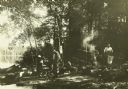
| Description: | The Gang at their camp in a shady spot by Burntside Lake. The canoes are in the water on the left. |

| Date: | 1911 |
|---|---|
| Description: | Carl, and one of The Gang standing with a dog, are bathing in Sturgeon Lake. Another man is standing on the shore. |

| Date: | 1911 |
|---|---|
| Description: | View from a canoe of a moose feeding in the waters of Sturgeon Lake. The prow of the canoe is in the foreground. |
| Date: | 1911 |
|---|---|
| Description: | An elevated view of the bridge and dam on the Old Dawson Trail at the end of Sturgeon Lake. The dam was built in 1873 by Simon Dawson. |

| Date: | 1911 |
|---|---|
| Description: | Clay, Doc Copeland, and Diadem (Di) the dog are in a canoe on what may be Namakan River or Lake. |
| Date: | 1911 |
|---|---|
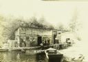
| Description: | View across water towards the Gang standing in front of G. Swenson's Store in Kettle Falls, which is partially on the water. The steamer schedule is handwr... |

| Date: | 1911 |
|---|---|
| Description: | Indian women paddle their canoes on Rainy Lake. Other people and dogs are on the shore. |

| Date: | 1911 |
|---|---|
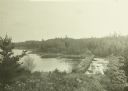
| Description: | View across water towards a large rock outcropping on Rainy Lake. |

| Date: | 08 1915 |
|---|---|
| Description: | The Gang at their camp near Crane Lake. Fog is hanging over the lake. |

| Date: | 08 1915 |
|---|---|
| Description: | A dramatic view through the Narrows between Sand Point and Namakan Lakes. |

| Date: | 08 1915 |
|---|---|
| Description: | The international boundary marker between the United States and Canada. This is on the Canadian side of Sand Point Lake in the Narrows between Sand Point a... |
If you didn't find the material you searched for, our Library Reference Staff can help.
Call our reference desk at 608-264-6535 or email us at:


