 Filter: Categories of Wisconsin Historical Images
Filter: Subject of Lakes
Filter: Creator Name of Foster, Mary Stuart
Filter: Categories of Wisconsin Historical Images
Filter: Subject of Lakes
Filter: Creator Name of Foster, Mary Stuart

| Date: | 1935 |
|---|---|
| Description: | This map shows Wisconsin’s pinery region. Lake Superior, Lake Michigan, Lake Winnebago, Green Bay, the Wisconsin River, and the Mississippi River are label... |
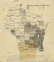
| Date: | 1918 |
|---|---|
| Description: | This map is ink on tracing paper showing all the counties of Wisconsin. The upper right hand corner contains a legend for distinguishing Wisconsin counties... |
If you didn't find the material you searched for, our Library Reference Staff can help.
Call our reference desk at 608-264-6535 or email us at: