 Filter: Categories of Wisconsin Historical Images
Filter: Subject of Lakes
Filter: Creator Name of C.N. Caspar Company
Filter: Categories of Wisconsin Historical Images
Filter: Subject of Lakes
Filter: Creator Name of C.N. Caspar Company

| Date: | 1886 |
|---|---|
| Description: | A hand-colored map of Milwaukee County, Wisconsin that shows the township and range system, sections, towns, roads, railroads and rail stations, cities and... |

| Date: | 1891 |
|---|---|
| Description: | A hand-colored map of Milwaukee County, Wisconsin that shows the township and range system, sections, towns, roads, railroads and rail stations, cities and... |
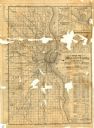
| Date: | 1886 |
|---|---|
| Description: | Two maps on one page. The first page is a map of Milwaukee County with insets "Plan of Pewaukee, Waukesha Co.," "Plan of Oconomowoc, Waukesha Co.," "Plan o... |

| Date: | 1918 |
|---|---|
| Description: | This map shows counties, cities, towns, villages, summer resorts, lakes, rivers, creeks, wagon roads, roads, railroads, and electric lines. The authentic a... |
If you didn't find the material you searched for, our Library Reference Staff can help.
Call our reference desk at 608-264-6535 or email us at: