 Filter: Categories of Wisconsin Historical Images
Filter: Subject of Lakes
Filter: Type of Map or Atlas
Filter: Subject of signs and symbols
Filter: Categories of Wisconsin Historical Images
Filter: Subject of Lakes
Filter: Type of Map or Atlas
Filter: Subject of signs and symbols

| Date: | 1949 |
|---|---|
| Description: | Color bird's-eye map of the University of Wisconsin-Madison as it was midcentury, with two co-eds, several photographs of campus landmarks around edges, an... |

| Date: | |
|---|---|
| Description: | Map reads: "Historic and Scenic Wisconsin — Land of Gathering Waters." In an inset there is a hand-painted depiction of the Wisconsin State Seal. For some ... |

| Date: | 1908 |
|---|---|
| Description: | A business map of Wisconsin, showing railroads, counties, cities, villages, rivers, and lakes. Additional areas shown in the map include the western portio... |

| Date: | 1950 |
|---|---|
| Description: | A map from the Wisconsin identifying the locations airports and other landing facilities in the state. On the opposite side the map includes an alphabetica... |

| Date: | 1923 |
|---|---|
| Description: | This early road map shows the system of roads in Wisconsin, northern Illinois, northeastern Iowa, southeastern Minnesota, and the western portion of Michig... |
| Date: | 1898 |
|---|---|
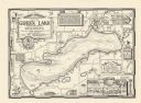
| Description: | A hydrographic map of Green Lake, Geneva, Wisconsin, and includes 5 cross sections of the depths at various points as well as along a line running the leng... |

| Date: | 1937 |
|---|---|
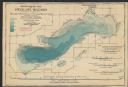
| Description: | A pictorial, hydrographic map shows sailing courses, historical and contemporary coastal attractions, roads, and the contour depths of Green Lake, Wisconsi... |
| Date: | 1970 |
|---|---|
| Description: | A pictorial map shows roads, parks, points of interest, keys to the property owners' association directory, and the contour depths of Green Lake, Wisconsin... |
| Date: | |
|---|---|
| Description: | A map of the Northern Baptist Assembly estate on the shore of Green Lake, Green Lake County, Wisconsin shows roads, buildings, and private homes. An inset ... |

| Date: | 1991 |
|---|---|
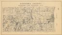
| Description: | This 1991 map of Burnett County, Wisconsin, shows Governor Knowles State Forest, wildlife areas, public hunting grounds, and other outdoor recreation facil... |

| Date: | 1953 |
|---|---|
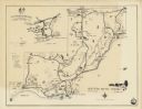
| Description: | This is a detailed map of Douglas County, Wisconsin, showing townships and township borders, numbered wards, roadways, and bodies of water. There are annot... |

| Date: | 1875 |
|---|---|
| Description: | This map, from G.K. Warren's 1876 Report on the transportation route along the Wisconsin and Fox rivers in the State of Wisconsin between the Mississippi R... |

| Date: | 1863 |
|---|---|
| Description: | Includes index to public buildings, churches, schools. Inset: Glidden & Lockwood’s addition. Gives names of some property owners. |

| Date: | 1880 |
|---|---|
| Description: | Map created from original drawing and surveys taken by Silas Chapman. Bottom right corner features a reference key. There is a street guide on the left sid... |

| Date: | 1937 |
|---|---|
| Description: | Includes points of interests in Madison and on the University of Wisconsin-Madison campus. Includes list of presidents of University of Wisconsin, 1849-193... |

| Date: | 1990 |
|---|---|
| Description: | Map of bike routes in Madison. Lower right corner features a system map with legend. Upper left corner is an inset of the Capital Loop with labelled points... |

| Date: | 1910 |
|---|---|
| Description: | Shows existing and proposed parks, railroads, and marshes in a color coded key. "Contour interval 20 feet." Lake Wingra, Lake Mendota, and Lake Monona are ... |

| Date: | 1927 |
|---|---|
| Description: | Map reads: "Now You Can Visualize Madison". Includes indexes, with points marked 1-98 and a key. Text and illustrations on verso include hotels and seasona... |
| Date: | 1934 |
|---|---|
| Description: | A land inventory map of Kenosha County. The top left features a legend of "Land Cover" and "Roads and Other Improvements". Lake Michigan is labelled to the... |
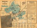
| Date: | 1950 |
|---|---|
| Description: | This map of Madison is also a brochure of activities for vacationers in the area. The map includes indexes and some points of interest are shown pictoriall... |
If you didn't find the material you searched for, our Library Reference Staff can help.
Call our reference desk at 608-264-6535 or email us at: