 Filter: Categories of Wisconsin Historical Images
Filter: Subject of Lakes
Filter: Type of Map or Atlas
Filter: Community of Milwaukee
Filter: Categories of Wisconsin Historical Images
Filter: Subject of Lakes
Filter: Type of Map or Atlas
Filter: Community of Milwaukee

| Date: | 1856 |
|---|---|
| Description: | View looking west from Lake Michigan with several steam ships and sailing vessels in harbor. There is a lighthouse to left of center, along shoreline. |

| Date: | 1898 |
|---|---|
| Description: | Bird's-eye map, looking west from shoreline on Lake Michigan of Milwaukee to Golden Lake in Waukesha County, with Kenosha and Fox Point at bottom corners, ... |

| Date: | 1908 |
|---|---|
| Description: | Colored map in perspective indicates railroad routes. Lake Winnebago and Oshkosh in center, area extends to Shawano (top right corner), Green Bay (bottom r... |

| Date: | 1876 |
|---|---|
| Description: | Map of home and land, with the roads, lakes, railroad, and buildings. |

| Date: | 1836 |
|---|---|
| Description: | This hand-colored manuscript map shows the township and section grid in southeastern Wisconsin, covering the area west to Sugar River and Four Lakes region... |

| Date: | 1858 |
|---|---|
| Description: | An ink on paper map of Milwaukee County and the eastern portion of Waukesha County that shows the townships of Oak Creek, Franklin, Greenfield, Wauwatosa, ... |

| Date: | 1886 |
|---|---|
| Description: | A hand-colored map of Milwaukee County, Wisconsin that shows the township and range system, sections, towns, roads, railroads and rail stations, cities and... |

| Date: | 1891 |
|---|---|
| Description: | A hand-colored map of Milwaukee County, Wisconsin that shows the township and range system, sections, towns, roads, railroads and rail stations, cities and... |

| Date: | 1838 |
|---|---|
| Description: | A map of the proposed route of the Milwaukee and Rock River Canal from Fort Atkinson on the Rock River in the west to the city of Milwaukee and Lake Michig... |

| Date: | 1830 |
|---|---|
| Description: | An ink on paper, hand-drawn map of the town of Milwaukee, showing the divisions and landownership within the town by private individuals as well as those l... |

| Date: | 1863 |
|---|---|
| Description: | Includes index to public buildings, churches, schools. Inset: Glidden & Lockwood’s addition. Gives names of some property owners. |

| Date: | 1877 |
|---|---|
| Description: | Two maps on one page, removed from an atlas. The first map shows Wisconsin and the upper peninsula of Michigan counties and townships while the second map ... |

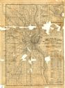
| Date: | 1880 |
|---|---|
| Description: | Map created from original drawing and surveys taken by Silas Chapman. Bottom right corner features a reference key. There is a street guide on the left sid... |
| Date: | 1886 |
|---|---|
| Description: | Two maps on one page. The first page is a map of Milwaukee County with insets "Plan of Pewaukee, Waukesha Co.," "Plan of Oconomowoc, Waukesha Co.," "Plan o... |

| Date: | 1940 |
|---|---|
| Description: | This map is pen and ink on paper and is 1 map consisting of 12 sheets. This map includes a numbered key labeling each area, all of which are represented ... |

| Date: | 1940 |
|---|---|
| Description: | Shows Milwaukee and Waukesha counties, and parts of Dodge, Washington, Ozaukee, Jefferson, Walworth, and Racine counties. Includes indexes of "Cities, Town... |

| Date: | 04 04 1934 |
|---|---|
| Description: | Street map of the city of Milwaukee and surrounding communities at a scale of 1 inch to 1200 feet. |

| Date: | 1951 |
|---|---|
| Description: | This map is a survey of Lake Michigan and the section of Milwaukee that borders the lake. Map of land includes major streets, and landmarks near water. Rel... |

| Date: | 1880 |
|---|---|
| Description: | This map shows wards, roads, railroads, lot and block numbers, subdivisions, parks, and some landownership. A handwritten annotation in red reads: "Note: S... |

| Date: | 1845 |
|---|---|
| Description: | Map of Wisconsin, including lower western border with Iowa, southern border along Illinois, eastern shoreline of Lake Michigan, and northern area along Wis... |
If you didn't find the material you searched for, our Library Reference Staff can help.
Call our reference desk at 608-264-6535 or email us at: