 Filter: Categories of Wisconsin Historical Images
Filter: Subject of Lac du Flambeau
Filter: Subject of transportation
Filter: Categories of Wisconsin Historical Images
Filter: Subject of Lac du Flambeau
Filter: Subject of transportation
| Date: | |
|---|---|
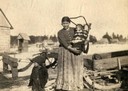
| Description: | A Chippewa (Ojibwa) mother with two children, one of whom is in a cradleboard, at the Lac du Flambeau reservation. This image is part of an exhibit about N... |
| Date: | |
|---|---|
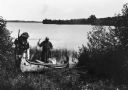
| Description: | Two Indians are launching a new canoe, possibly on Flambeau Lake. |
| Date: | |
|---|---|
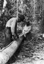
| Description: | Ojibwa Indians splitting bark off a birch tree. The bark will be used to make a canoe. |
| Date: | |
|---|---|
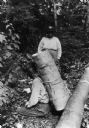
| Description: | An Ojibwa man has a pack of birch bark on his back to carry to the canoe-making site. Another person is standing behind him. |
| Date: | |
|---|---|
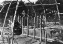
| Description: | An Ojibwa man shaping birch bark in a frame during the process of making a canoe. |

| Date: | 1864 |
|---|---|
| Description: | This map of the entire state of Wisconsin depicts the township survey grid and identifies counties, named towns, cities and villages, rivers, lakes, railro... |

| Date: | 1873 |
|---|---|
| Description: | This hand-colored map of Wisconsin depicts the township survey grid and identifies counties, named towns, cities and villages, rivers, lakes, railroads, an... |

| Date: | 1922 |
|---|---|
| Description: | A map of Iron County, Wisconsin, shows sections and the towns of Upson, Hurley, Hamilton, Saxon, and Mercer, lakes and streams, villages, railroads, roads ... |

| Date: | 1932 |
|---|---|
| Description: | A map of Iron County, Wisconsin, shows towns and sections, lakes and streams, villages, railroads, roads, and La Point and Lac Du Flambeau Indian reservati... |

| Date: | |
|---|---|
| Description: | A map of Iron County, Wisconsin, shows color-coded townships, sections, lakes and streams, villages, railroads, roads, tourist camps, and La Pointe and Lac... |

| Date: | 1939 |
|---|---|
| Description: | This illustrated map shows counties, highways, rivers, roads, present and proposed state parks and forests, proposed state parkways, proposed state monumen... |

| Date: | 1853 |
|---|---|
| Description: | This map shows camps, forts, logging camps, lakes, roads, railroads, the Wisconsin River, and Lac Du Flambeau Indian Reservation. Some points of interest a... |

| Date: | 1911 |
|---|---|
| Description: | This map shows railroads, roads, swamps, a school site and farm, and a mill site. The map includes a "typical township" diagram. Lac du Flambeau, Long Lake... |

| Date: | 1935 |
|---|---|
| Description: | This map shows railroads, telephone lines, roads, trails, schools, sub-agency, lookout stations, churches, community centers, and school site and farm. Bil... |

| Date: | 1994 |
|---|---|
| Description: | This map shows historical sites, picnic grounds, public boat landings, canoe and motor boat trips, and resort locations. The left margin of the map include... |
| Date: | 1936 |
|---|---|
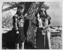
| Description: | Walker Reid (1929-2016) standing alongside tree with Indian girl. Reid Walker shown is 7-years-old, and is the son of Carol McMillan Reid. Portrait taken a... |

| Date: | |
|---|---|
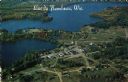
| Description: | Kodachrome postcard of an aerial view of Lac du Flambeau village and the surrounding chain of lakes. Caption reads: "Lac du Flambeau, Wisconsin." Text on b... |
| Date: | 1984 |
|---|---|
| Description: | Aerial postcard of Lac du Flambeau village and surrounding lakes. Caption reads: "Lac du Flambeau, Wis." Text on reverse reads: "On State Hwy 47 between Po... |
If you didn't find the material you searched for, our Library Reference Staff can help.
Call our reference desk at 608-264-6535 or email us at: